Tancarville geodata
Tancarville (Normandy) is a populated place; located in France in Europe/Paris (GMT+2) time zone. With population of 1,267 people, there are 7198 cities with bigger population in this country. Compared to other cities in France, 89% of cities are located further ↓South; 73.8% of cities are located further →East and 65.6% of cities have higher elevation than Tancarville. Note1
Administrative division(s):
- Level 1: Normandy
- Level 2: Seine-Maritime
- Level 3: Arrondissement du Havre
- Level 4: Tancarville


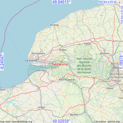
Tancarville GPS coordinates[2]
49° 29' 7.8" North, 0° 27' 27.54" East
| Map corner | latitude | longitude |
|---|---|---|
| Upper-left | 49.94015°, | -0.24547° |
| Center: | 49.4855°, | 0.45765° |
| Lower-right: | 49.02659°, | 1.16078° |
| Map W x H: | 101.6×101.6 km | = 63.1×63.1mi |
| max Lat: | 51.07786° ⇑11% North |
| Tancarville: | 49.4855° |
| min Lat: | ⇓89% South 41.3874° |
| min Long | Tancarville | max Long |
| -5.08615° | 0.45765° | 9.52242° |
| W 26.2%⇐ | ⇒73.8% E |
Elevation
Elevation of Tancarville is 88 m = 289 ft, and this is 105.7 m = 347 ft below average elevation for this country.
| Max E: |
2333 m = 7654 ft | 65.6% |
| Avg. | 193.7 m = 635 ft | |
| Tancarville | 88 m = 289 ft | |
Min E: |
-1 m = -3 ft | 34.4% |
See also: France elevation on elevation.city.
Geographical zone
Tancarville is located in North temperate zone (between Tropic of Cancer and the Arctic Circle). Distance of this North polar circle is 1898.9 km =1179.9 mi to North.| Distance of | km | miles | from Tancarville |
|---|---|---|---|
| North Pole | 4504.8 | 2799.2 | to North |
| Arctic Circle | 1898.9 | 1179.9 | to North |
| Tropic Cancer | 2896.4 | 1799.7 | to South |
| Equator | 5502.3 | 3419 | to South |


Nearby cities:
15 places around Tancarville: (largest is in red/bold)
• Conteville
8.7 km =5.4 mi,  210°
210°
• Gruchet-le-Valasse
8 km =5 mi,  15°
15°
• La Cerlangue
3.9 km =2.4 mi,  305°
305°
• La Remuée
6.1 km =3.8 mi,  319°
319°
• Les Trois-Pierres
7.8 km =4.8 mi,  337°
337°
• Lillebonne
6.9 km =4.3 mi,  55°
55°
• Mélamare
5.7 km =3.5 mi,  358°
358°
• Notre-Dame-de-Gravenchon
8.3 km =5.2 mi,  86°
86°
• Quillebeuf-sur-Seine
5.4 km =3.4 mi,  109°
109°
• Saint-Antoine-la-Forêt
5.8 km =3.6 mi,  12°
12°
• Saint-Eustache-la-Forêt
7.3 km =4.5 mi, 359°
• Saint-Jean-de-Folleville
5.3 km =3.3 mi,  40°
40°
• Saint-Nicolas-de-la-Taille
3.1 km =1.9 mi, 22°
• Saint-Romain-de-Colbosc
8.8 km =5.5 mi,  304°
304°
• Saint-Vincent-Cramesnil
7.3 km =4.5 mi,  285°
285°
Sources, notices
• [Note1] Compared only with cities in France existing in our database
• [Src1] Map data: © OpenStreetMap contributors (CC-BY-SA)
• [Src2] Other city data from geonames.org with taken over terms of usage.
• [Src3] Geographical zone / Annual Mean Temperature by Robert A. Rohde @ Wikipedia
