Naucelles geodata
Naucelles (Auvergne-Rhône-Alpes) is a populated place; located in France in Europe/Paris (GMT+2) time zone. With population of 1,815 people, there are 5224 cities with bigger population in this country. Compared to other cities in France, 80% of cities are located further ↑North; 50.8% of cities are located further →East and 97.2% of cities have lower elevation than Naucelles. Note1
Administrative division(s):
- Level 1: Auvergne-Rhône-Alpes
- Level 2: Cantal
- Level 3: Aurillac
- Level 4: Naucelles


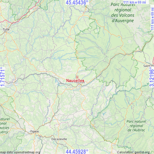
Naucelles GPS coordinates[2]
44° 57' 32.328" North, 2° 25' 7.824" East
| Map corner | latitude | longitude |
|---|---|---|
| Upper-left | 45.45436°, | 1.71571° |
| Center: | 44.95898°, | 2.41884° |
| Lower-right: | 44.45928°, | 3.12196° |
| Map W x H: | 110.6×110.6 km | = 68.7×68.7mi |
| max Lat: | 51.07786° ⇑80% North |
| Naucelles: | 44.95898° |
| min Lat: | ⇓20% South 41.3874° |
| min Long | Naucelles | max Long |
| -5.08615° | 2.41884° | 9.52242° |
| W 49.2%⇐ | ⇒50.8% E |
Elevation
Elevation of Naucelles is 740 m = 2428 ft, and this is 546.3 m = 1792 ft above average elevation for this country.
| Max E: |
2333 m = 7654 ft | 2.8% |
| Naucelles | 740 m 2428 ft | |
| Avg. | 193.7 m = 635 ft | |
Min E: |
-1 m = -3 ft | 97.2% |
See also: France elevation on elevation.city.
Geographical zone
Naucelles is located in North temperate zone (between Tropic of Cancer and the Arctic Circle). Distance of this Northern Tropic circle is 2393.1 km =1487 mi to South.| Distance of | km | miles | from Naucelles |
|---|---|---|---|
| North Pole | 5008.1 | 3111.9 | to North |
| Arctic Circle | 2402.2 | 1492.7 | to North |
| Tropic Cancer | 2393.1 | 1487 | to South |
| Equator | 4999 | 3106.2 | to South |


Nearby cities:
15 places around Naucelles: (largest is in red/bold)
• Arpajon-sur-Cère
6.8 km =4.2 mi,  154°
154°
• Aurillac
4.1 km =2.5 mi,  156°
156°
• Ayrens
7.8 km =4.8 mi,  291°
291°
• Giou-de-Mamou
8.1 km =5 mi,  111°
111°
• Jussac
3.2 km =2 mi,  5°
5°
• Marmanhac
7 km =4.3 mi,  45°
45°
• Polminhac
12.5 km =7.8 mi,  93°
93°
• Reilhac
1.6 km =1 mi, 6°
• Roannes-Saint-Mary
11.6 km =7.2 mi,  191°
191°
• Saint-Cernin
11.1 km =6.9 mi,  0°
0°
• Saint-Illide
14 km =8.7 mi,  324°
324°
• Saint-Paul-des-Landes
8.4 km =5.2 mi,  258°
258°
• Saint-Simon
5.6 km =3.5 mi, 85°
• Sansac-de-Marmiesse
10.1 km =6.3 mi,  213°
213°
• Ytrac
6.9 km =4.3 mi,  220°
220°
Sources, notices
• [Note1] Compared only with cities in France existing in our database
• [Src1] Map data: © OpenStreetMap contributors (CC-BY-SA)
• [Src2] Other city data from geonames.org with taken over terms of usage.
• [Src3] Geographical zone / Annual Mean Temperature by Robert A. Rohde @ Wikipedia
