Nantheuil geodata
Nantheuil (Nouvelle-Aquitaine) is a populated place; located in France in Europe/Paris (GMT+2) time zone. With population of 959 people, there are 9134 cities with bigger population in this country. Compared to other cities in France, 75.1% of cities are located further ↑North; 69.3% of cities are located further →East and 69.4% of cities have lower elevation than Nantheuil. Note1
Administrative division(s):
- Level 1: Nouvelle-Aquitaine
- Level 2: Dordogne
- Level 3: Arrondissement de Nontron
- Level 4: Nantheuil


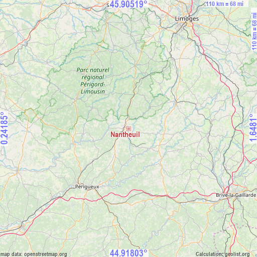
Nantheuil GPS coordinates[2]
45° 24' 49.572" North, 0° 56' 41.892" East
| Map corner | latitude | longitude |
|---|---|---|
| Upper-left | 45.90519°, | 0.24185° |
| Center: | 45.41377°, | 0.94497° |
| Lower-right: | 44.91803°, | 1.6481° |
| Map W x H: | 109.8×109.8 km | = 68.2×68.2mi |
| max Lat: | 51.07786° ⇑75.1% North |
| Nantheuil: | 45.41377° |
| min Lat: | ⇓24.9% South 41.3874° |
| min Long | Nantheuil | max Long |
| -5.08615° | 0.94497° | 9.52242° |
| W 30.7%⇐ | ⇒69.3% E |
Elevation
Elevation of Nantheuil is 216 m = 709 ft, and this is 22.3 m = 73 ft above average elevation for this country.
| Max E: |
2333 m = 7654 ft | 30.6% |
| Nantheuil | 216 m 709 ft | |
| Avg. | 193.7 m = 635 ft | |
Min E: |
-1 m = -3 ft | 69.4% |
See also: France elevation on elevation.city.
Geographical zone
Nantheuil is located in North temperate zone (between Tropic of Cancer and the Arctic Circle). Distance of this North polar circle is 2351.6 km =1461.2 mi to North.| Distance of | km | miles | from Nantheuil |
|---|---|---|---|
| North Pole | 4957.5 | 3080.4 | to North |
| Arctic Circle | 2351.6 | 1461.2 | to North |
| Tropic Cancer | 2443.6 | 1518.4 | to South |
| Equator | 5049.5 | 3137.6 | to South |


Nearby cities:
15 places around Nantheuil: (largest is in red/bold)
• Angoisse
15.1 km =9.4 mi,  84°
84°
• Coulaures
12.2 km =7.6 mi,  167°
167°
• Excideuil
11.8 km =7.3 mi,  137°
137°
• Eyzerac
3.4 km =2.1 mi,  214°
214°
• Jumilhac-le-Grand
12.9 km =8 mi,  45°
45°
• La Coquille
14.5 km =9 mi,  9°
9°
• Lanouaille
15.3 km =9.5 mi,  97°
97°
• Mialet
15.4 km =9.6 mi,  348°
348°
• Milhac-de-Nontron
14.1 km =8.8 mi,  295°
295°
• Négrondes
10 km =6.2 mi,  218°
218°
• Saint-Jory-de-Chalais
10.2 km =6.3 mi,  339°
339°
• Saint-Paul-la-Roche
8.3 km =5.2 mi,  30°
30°
• Sorges
13.3 km =8.3 mi,  204°
204°
• Thiviers
2 km =1.2 mi,  275°
275°
• Villars
14.9 km =9.3 mi,  272°
272°
Sources, notices
• [Note1] Compared only with cities in France existing in our database
• [Src1] Map data: © OpenStreetMap contributors (CC-BY-SA)
• [Src2] Other city data from geonames.org with taken over terms of usage.
• [Src3] Geographical zone / Annual Mean Temperature by Robert A. Rohde @ Wikipedia
