Morsang-sur-Orge geodata
Morsang-sur-Orge (Île-de-France) is a populated place; located in France in Europe/Paris (GMT+2) time zone. With population of 19,917 people, there are 459 cities with bigger population in this country. Compared to other cities in France, 72.3% of cities are located further ↓South; 51.8% of cities are located further →East and 71% of cities have higher elevation than Morsang-sur-Orge. Note1
Administrative division(s):
- Level 1: Île-de-France
- Level 2: Département de l'Essonne
- Level 3: Arrondissement d'Évry
- Level 4: Morsang-sur-Orge


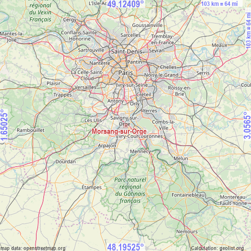
Morsang-sur-Orge GPS coordinates[2]
48° 39' 42.516" North, 2° 21' 12.168" East
| Map corner | latitude | longitude |
|---|---|---|
| Upper-left | 49.12409°, | 1.65025° |
| Center: | 48.66181°, | 2.35338° |
| Lower-right: | 48.19525°, | 3.0565° |
| Map W x H: | 103.3×103.3 km | = 64.2×64.2mi |
| max Lat: | 51.07786° ⇑27.7% North |
| Morsang-sur-Orge: | 48.66181° |
| min Lat: | ⇓72.3% South 41.3874° |
| min Long | Morsang-sur-Org | max Long |
| -5.08615° | 2.35338° | 9.52242° |
| W 48.2%⇐ | ⇒51.8% E |
Elevation
Elevation of Morsang-sur-Orge is 76 m = 249 ft, and this is 117.7 m = 386 ft below average elevation for this country.
| Max E: |
2333 m = 7654 ft | 71% |
| Avg. | 193.7 m = 635 ft | |
| Morsang-sur-Orge | 76 m = 249 ft | |
Min E: |
-1 m = -3 ft | 29% |
See also: France elevation on elevation.city.
Geographical zone
Morsang-sur-Orge is located in North temperate zone (between Tropic of Cancer and the Arctic Circle). Distance of this North polar circle is 1990.5 km =1236.8 mi to North.| Distance of | km | miles | from Morsang-sur-Orge |
|---|---|---|---|
| North Pole | 4596.4 | 2856.1 | to North |
| Arctic Circle | 1990.5 | 1236.8 | to North |
| Tropic Cancer | 2804.8 | 1742.8 | to South |
| Equator | 5410.7 | 3362.1 | to South |


Nearby cities:
15 places around Morsang-sur-Orge: (largest is in red/bold)
• Ballainvilliers
4.1 km =2.5 mi,  290°
290°
• Fleury-Mérogis
2.8 km =1.7 mi,  164°
164°
• Grigny
3.1 km =1.9 mi,  106°
106°
• Juvisy-sur-Orge
3.2 km =2 mi,  42°
42°
• Longjumeau
5 km =3.1 mi,  317°
317°
• Longpont-sur-Orge
5 km =3.1 mi,  243°
243°
• Morangis
4.8 km =3 mi,  347°
347°
• Ris-Orangis
4.6 km =2.9 mi,  104°
104°
• Saint-Michel-sur-Orge
4.5 km =2.8 mi,  227°
227°
• Sainte-Geneviève-des-Bois
3 km =1.9 mi, 236°
• Savigny-sur-Orge
1.7 km =1.1 mi, 347°
• Villemoisson-sur-Orge
1.3 km =0.8 mi, 292°
• Villiers-sur-Orge
3.9 km =2.4 mi,  266°
266°
• Viry-Châtillon
3.1 km =1.9 mi,  68°
68°
• Épinay-sur-Orge
3.4 km =2.1 mi, 292°
Sources, notices
• [Note1] Compared only with cities in France existing in our database
• [Src1] Map data: © OpenStreetMap contributors (CC-BY-SA)
• [Src2] Other city data from geonames.org with taken over terms of usage.
• [Src3] Geographical zone / Annual Mean Temperature by Robert A. Rohde @ Wikipedia
