Longjumeau geodata
Longjumeau (Île-de-France) is a populated place; located in France in Europe/Paris (GMT+2) time zone. With population of 20,771 people, there are 439 cities with bigger population in this country. Compared to other cities in France, 73.1% of cities are located further ↓South; 52.6% of cities are located further →East and 83.8% of cities have higher elevation than Longjumeau. Note1
Administrative division(s):
- Level 1: Île-de-France
- Level 2: Département de l'Essonne
- Level 3: Arrondissement de Palaiseau
- Level 4: Longjumeau


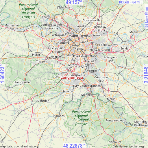
Longjumeau GPS coordinates[2]
48° 41' 42.108" North, 2° 18' 26.46" East
| Map corner | latitude | longitude |
|---|---|---|
| Upper-left | 49.157°, | 1.60423° |
| Center: | 48.69503°, | 2.30735° |
| Lower-right: | 48.22878°, | 3.01048° |
| Map W x H: | 103.2×103.2 km | = 64.1×64.1mi |
| max Lat: | 51.07786° ⇑26.9% North |
| Longjumeau: | 48.69503° |
| min Lat: | ⇓73.1% South 41.3874° |
| min Long | Longjumeau | max Long |
| -5.08615° | 2.30735° | 9.52242° |
| W 47.4%⇐ | ⇒52.6% E |
Elevation
Elevation of Longjumeau is 45 m = 148 ft, and this is 148.7 m = 488 ft below average elevation for this country.
| Max E: |
2333 m = 7654 ft | 83.8% |
| Avg. | 193.7 m = 635 ft | |
| Longjumeau | 45 m = 148 ft | |
Min E: |
-1 m = -3 ft | 16.2% |
See also: France elevation on elevation.city.
Geographical zone
Longjumeau is located in North temperate zone (between Tropic of Cancer and the Arctic Circle). Distance of this North polar circle is 1986.8 km =1234.5 mi to North.| Distance of | km | miles | from Longjumeau |
|---|---|---|---|
| North Pole | 4592.7 | 2853.8 | to North |
| Arctic Circle | 1986.8 | 1234.5 | to North |
| Tropic Cancer | 2808.5 | 1745.1 | to South |
| Equator | 5414.4 | 3364.4 | to South |


Nearby cities:
15 places around Longjumeau: (largest is in red/bold)
• Ballainvilliers
2.3 km =1.4 mi,  192°
192°
• Champlan
2.5 km =1.6 mi,  305°
305°
• Chilly-Mazarin
2.3 km =1.4 mi,  16°
16°
• Massy
4 km =2.5 mi,  333°
333°
• Morangis
2.5 km =1.6 mi,  67°
67°
• Morsang-sur-Orge
5 km =3.1 mi,  137°
137°
• Palaiseau
5 km =3.1 mi,  301°
301°
• Paray-Vieille-Poste
4.6 km =2.9 mi,  62°
62°
• Saulx-les-Chartreux
3 km =1.9 mi,  260°
260°
• Savigny-sur-Orge
3.6 km =2.2 mi,  124°
124°
• Villebon-sur-Yvette
5.1 km =3.2 mi,  283°
283°
• Villemoisson-sur-Orge
3.8 km =2.4 mi,  146°
146°
• Villiers-sur-Orge
4 km =2.5 mi, 187°
• Wissous
4.4 km =2.7 mi, 15°
• Épinay-sur-Orge
2.4 km =1.5 mi,  174°
174°
Sources, notices
• [Note1] Compared only with cities in France existing in our database
• [Src1] Map data: © OpenStreetMap contributors (CC-BY-SA)
• [Src2] Other city data from geonames.org with taken over terms of usage.
• [Src3] Geographical zone / Annual Mean Temperature by Robert A. Rohde @ Wikipedia
