Montigny-en-Gohelle geodata
Montigny-en-Gohelle (Hauts-de-France) is a populated place; located in France in Europe/Paris (GMT+2) time zone. With population of 10,713 people, there are 893 cities with bigger population in this country. Compared to other cities in France, 96.7% of cities are located further ↓South; 56.9% of cities are located further ←West and 89.1% of cities have higher elevation than Montigny-en-Gohelle. Note1
Administrative division(s):
- Level 1: Hauts-de-France
- Level 2: Pas-de-Calais
- Level 3: Arrondissement de Lens
- Level 4: Montigny-en-Gohelle


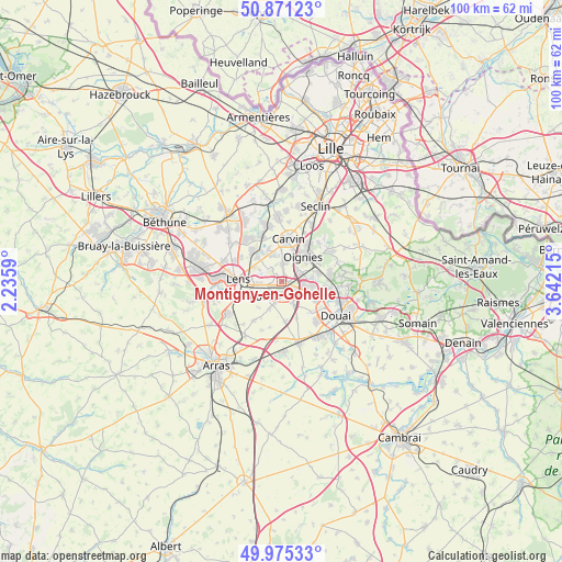
Montigny-en-Gohelle GPS coordinates[2]
50° 25' 31.44" North, 2° 56' 20.472" East
| Map corner | latitude | longitude |
|---|---|---|
| Upper-left | 50.87123°, | 2.2359° |
| Center: | 50.4254°, | 2.93902° |
| Lower-right: | 49.97533°, | 3.64215° |
| Map W x H: | 99.6×99.6 km | = 61.9×61.9mi |
| max Lat: | 51.07786° ⇑3.3% North |
| Montigny-en-Gohelle: | 50.4254° |
| min Lat: | ⇓96.7% South 41.3874° |
| min Long | Montigny-en-Goh | max Long |
| -5.08615° | 2.93902° | 9.52242° |
| W 56.9%⇐ | ⇒43.1% E |
Elevation
Elevation of Montigny-en-Gohelle is 32 m = 105 ft, and this is 161.7 m = 531 ft below average elevation for this country.
| Max E: |
2333 m = 7654 ft | 89.1% |
| Avg. | 193.7 m = 635 ft | |
| Montigny-en-Gohelle | 32 m = 105 ft | |
Min E: |
-1 m = -3 ft | 10.9% |
See also: France elevation on elevation.city.
Geographical zone
Montigny-en-Gohelle is located in North temperate zone (between Tropic of Cancer and the Arctic Circle). Distance of this North polar circle is 1794.4 km =1115 mi to North.| Distance of | km | miles | from Montigny-en-Gohelle |
|---|---|---|---|
| North Pole | 4400.3 | 2734.2 | to North |
| Arctic Circle | 1794.4 | 1115 | to North |
| Tropic Cancer | 3000.9 | 1864.7 | to South |
| Equator | 5606.8 | 3483.9 | to South |


Nearby cities:
15 places around Montigny-en-Gohelle: (largest is in red/bold)
• Annay
5.9 km =3.7 mi,  315°
315°
• Billy-Montigny
2.7 km =1.7 mi,  250°
250°
• Bois-Bernard
5.3 km =3.3 mi,  201°
201°
• Courcelles-lès-Lens
5.6 km =3.5 mi,  100°
100°
• Courrières
3.6 km =2.2 mi,  9°
9°
• Dourges
3.5 km =2.2 mi,  69°
69°
• Drocourt
4.1 km =2.5 mi,  194°
194°
• Fouquières-lès-Lens
1.9 km =1.2 mi,  280°
280°
• Harnes
3.4 km =2.1 mi,  313°
313°
• Hénin-Beaumont
2.3 km =1.4 mi,  125°
125°
• Noyelles-Godault
3.9 km =2.4 mi, 102°
• Noyelles-sous-Lens
4.8 km =3 mi, 277°
• Oignies
5.7 km =3.5 mi,  42°
42°
• Rouvroy
4.4 km =2.7 mi,  214°
214°
• Sallaumines
5.5 km =3.4 mi,  260°
260°
Sources, notices
• [Note1] Compared only with cities in France existing in our database
• [Src1] Map data: © OpenStreetMap contributors (CC-BY-SA)
• [Src2] Other city data from geonames.org with taken over terms of usage.
• [Src3] Geographical zone / Annual Mean Temperature by Robert A. Rohde @ Wikipedia
