Montchevrier geodata
Montchevrier (Centre) is a populated place; located in France in Europe/Paris (GMT+2) time zone. With population of 537 people, there are 14448 cities with bigger population in this country. Compared to other cities in France, 60.3% of cities are located further ↑North; 60% of cities are located further →East and 84% of cities have lower elevation than Montchevrier. Note1
Administrative division(s):
- Level 1: Centre
- Level 2: Département de l'Indre
- Level 3: Arrondissement de La Châtre
- Level 4: Montchevrier


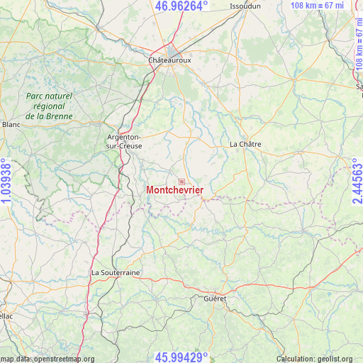
Montchevrier GPS coordinates[2]
46° 28' 50.232" North, 1° 44' 33" East
| Map corner | latitude | longitude |
|---|---|---|
| Upper-left | 46.96264°, | 1.03938° |
| Center: | 46.48062°, | 1.7425° |
| Lower-right: | 45.99429°, | 2.44563° |
| Map W x H: | 107.7×107.7 km | = 66.9×66.9mi |
| max Lat: | 51.07786° ⇑60.3% North |
| Montchevrier: | 46.48062° |
| min Lat: | ⇓39.7% South 41.3874° |
| min Long | Montchevrier | max Long |
| -5.08615° | 1.7425° | 9.52242° |
| W 40%⇐ | ⇒60% E |
Elevation
Elevation of Montchevrier is 335 m = 1099 ft, and this is 141.3 m = 464 ft above average elevation for this country.
| Max E: |
2333 m = 7654 ft | 16% |
| Montchevrier | 335 m 1099 ft | |
| Avg. | 193.7 m = 635 ft | |
Min E: |
-1 m = -3 ft | 84% |
See also: France elevation on elevation.city.
Geographical zone
Montchevrier is located in North temperate zone (between Tropic of Cancer and the Arctic Circle). Distance of this North polar circle is 2233 km =1387.5 mi to North.| Distance of | km | miles | from Montchevrier |
|---|---|---|---|
| North Pole | 4838.9 | 3006.8 | to North |
| Arctic Circle | 2233 | 1387.5 | to North |
| Tropic Cancer | 2562.2 | 1592.1 | to South |
| Equator | 5168.2 | 3211.4 | to South |


Nearby cities:
15 places around Montchevrier: (largest is in red/bold)
• Aigurande
8.5 km =5.3 mi,  127°
127°
• Badecon-le-Pin
13.1 km =8.1 mi,  300°
300°
• Ceaulmont
13.6 km =8.5 mi,  290°
290°
• Chantôme
16.3 km =10.1 mi,  241°
241°
• Chassignolles
16.5 km =10.3 mi,  65°
65°
• Chéniers
15.8 km =9.8 mi,  155°
155°
• Cluis
7.2 km =4.5 mi,  4°
4°
• Crozant
13.5 km =8.4 mi,  223°
223°
• Cuzion
10.4 km =6.5 mi,  269°
269°
• Fresselines
11.8 km =7.3 mi,  202°
202°
• Lourdoueix-Saint-Pierre
10 km =6.2 mi,  142°
142°
• Méasnes
7.6 km =4.7 mi, 159°
• Neuvy-Saint-Sépulchre
13.9 km =8.6 mi,  20°
20°
• Orsennes
4.6 km =2.9 mi,  264°
264°
• Éguzon-Chantôme
12.7 km =7.9 mi,  254°
254°
Sources, notices
• [Note1] Compared only with cities in France existing in our database
• [Src1] Map data: © OpenStreetMap contributors (CC-BY-SA)
• [Src2] Other city data from geonames.org with taken over terms of usage.
• [Src3] Geographical zone / Annual Mean Temperature by Robert A. Rohde @ Wikipedia
