Chantôme geodata
Chantôme (Centre) is a populated place; located in France in Europe/Paris (GMT+2) time zone. With population of 1,372 people, there are 6718 cities with bigger population in this country. Compared to other cities in France, 60.9% of cities are located further ↑North; 62.3% of cities are located further →East and 80.7% of cities have lower elevation than Chantôme. Note1
Administrative division(s):
- Level 1: Centre
- Level 2: Département de l'Indre
- Level 3: Arrondissement de Châteauroux
- Level 4: Éguzon-Chantôme


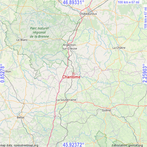
Chantôme GPS coordinates[2]
46° 24' 38.412" North, 1° 33' 21.24" East
| Map corner | latitude | longitude |
|---|---|---|
| Upper-left | 46.89331°, | 0.85278° |
| Center: | 46.41067°, | 1.5559° |
| Lower-right: | 45.92372°, | 2.25903° |
| Map W x H: | 107.8×107.8 km | = 67×67mi |
| max Lat: | 51.07786° ⇑60.9% North |
| Chantôme: | 46.41067° |
| min Lat: | ⇓39.1% South 41.3874° |
| min Long | Chantôme | max Long |
| -5.08615° | 1.5559° | 9.52242° |
| W 37.7%⇐ | ⇒62.3% E |
Elevation
Elevation of Chantôme is 298 m = 978 ft, and this is 104.3 m = 342 ft above average elevation for this country.
| Max E: |
2333 m = 7654 ft | 19.3% |
| Chantôme | 298 m 978 ft | |
| Avg. | 193.7 m = 635 ft | |
Min E: |
-1 m = -3 ft | 80.7% |
See also: France elevation on elevation.city.
Geographical zone
Chantôme is located in North temperate zone (between Tropic of Cancer and the Arctic Circle). Distance of this North polar circle is 2240.8 km =1392.4 mi to North.| Distance of | km | miles | from Chantôme |
|---|---|---|---|
| North Pole | 4846.7 | 3011.6 | to North |
| Arctic Circle | 2240.8 | 1392.4 | to North |
| Tropic Cancer | 2554.5 | 1587.3 | to South |
| Equator | 5160.4 | 3206.5 | to South |


Nearby cities:
15 places around Chantôme: (largest is in red/bold)
• Azerables
8.9 km =5.5 mi,  224°
224°
• Badecon-le-Pin
14.8 km =9.2 mi,  11°
11°
• Ceaulmont
12.6 km =7.8 mi, 6°
• Crozant
5.4 km =3.4 mi,  112°
112°
• Cuzion
8.6 km =5.3 mi,  27°
27°
• Dun-le-Palestel
14.3 km =8.9 mi,  144°
144°
• Fresselines
10.2 km =6.3 mi, 107°
• La Châtre-Langlin
12.8 km =8 mi,  269°
269°
• Montchevrier
16.3 km =10.1 mi,  61°
61°
• Orsennes
12.2 km =7.6 mi,  53°
53°
• Parnac
9.9 km =6.2 mi,  298°
298°
• Saint-Agnant-de-Versillat
15.1 km =9.4 mi,  193°
193°
• Saint-Benoît-du-Sault
13.1 km =8.1 mi,  284°
284°
• Saint-Sébastien
2.9 km =1.8 mi, 221°
• Éguzon-Chantôme
4.9 km =3 mi, 25°
Sources, notices
• [Note1] Compared only with cities in France existing in our database
• [Src1] Map data: © OpenStreetMap contributors (CC-BY-SA)
• [Src2] Other city data from geonames.org with taken over terms of usage.
• [Src3] Geographical zone / Annual Mean Temperature by Robert A. Rohde @ Wikipedia
