Saint-Sulpice geodata
Saint-Sulpice (Auvergne-Rhône-Alpes) is a populated place; located in France in Europe/Paris (GMT+2) time zone. With population of 720 people, there are 11535 cities with bigger population in this country. Compared to other cities in France, 73.1% of cities are located further ↑North; 85.5% of cities are located further ←West and 94.3% of cities have lower elevation than Saint-Sulpice. Note1
Administrative division(s):
- Level 1: Auvergne-Rhône-Alpes
- Level 2: Savoie
- Level 3: Arrondissement de Chambéry
- Level 4: Saint-Sulpice


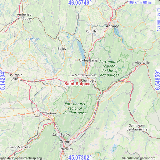
Saint-Sulpice GPS coordinates[2]
45° 34' 2.676" North, 5° 50' 43.656" East
| Map corner | latitude | longitude |
|---|---|---|
| Upper-left | 46.05749°, | 5.14234° |
| Center: | 45.56741°, | 5.84546° |
| Lower-right: | 45.07302°, | 6.54859° |
| Map W x H: | 109.5×109.5 km | = 68×68mi |
| max Lat: | 51.07786° ⇑73.1% North |
| Saint-Sulpice: | 45.56741° |
| min Lat: | ⇓26.9% South 41.3874° |
| min Long | Saint-Sulpice | max Long |
| -5.08615° | 5.84546° | 9.52242° |
| W 85.5%⇐ | ⇒14.5% E |
Elevation
Elevation of Saint-Sulpice is 552 m = 1811 ft, and this is 358.3 m = 1176 ft above average elevation for this country.
| Max E: |
2333 m = 7654 ft | 5.7% |
| Saint-Sulpice | 552 m 1811 ft | |
| Avg. | 193.7 m = 635 ft | |
Min E: |
-1 m = -3 ft | 94.3% |
See also: France elevation on elevation.city.
Geographical zone
Saint-Sulpice is located in North temperate zone (between Tropic of Cancer and the Arctic Circle). Distance of this North polar circle is 2334.6 km =1450.7 mi to North.| Distance of | km | miles | from Saint-Sulpice |
|---|---|---|---|
| North Pole | 4940.4 | 3069.8 | to North |
| Arctic Circle | 2334.6 | 1450.7 | to North |
| Tropic Cancer | 2460.7 | 1529 | to South |
| Equator | 5066.6 | 3148.2 | to South |


Nearby cities:
15 places around Saint-Sulpice: (largest is in red/bold)
• Attignat-Oncin
8.5 km =5.3 mi,  219°
219°
• Barberaz
7.6 km =4.7 mi,  94°
94°
• Bassens
7.3 km =4.5 mi,  82°
82°
• Chambéry
5.9 km =3.7 mi, 91°
• Cognin
3.7 km =2.3 mi,  103°
103°
• Jacob-Bellecombette
5.5 km =3.4 mi, 101°
• La Motte-Servolex
3.7 km =2.3 mi,  27°
27°
• Montagnole
6 km =3.7 mi,  119°
119°
• Novalaise
6.1 km =3.8 mi,  299°
299°
• Saint-Alban-Leysse
8.3 km =5.2 mi, 77°
• Saint-Cassin
5.2 km =3.2 mi,  133°
133°
• Saint-Thibaud-de-Couz
7.4 km =4.6 mi,  180°
180°
• Sonnaz
7.8 km =4.8 mi,  44°
44°
• Vimines
2.8 km =1.7 mi,  146°
146°
• Voglans
6.6 km =4.1 mi, 30°
Sources, notices
• [Note1] Compared only with cities in France existing in our database
• [Src1] Map data: © OpenStreetMap contributors (CC-BY-SA)
• [Src2] Other city data from geonames.org with taken over terms of usage.
• [Src3] Geographical zone / Annual Mean Temperature by Robert A. Rohde @ Wikipedia
