Mignovillard geodata
Mignovillard (Bourgogne-Franche-Comté) is a populated place; located in France in Europe/Paris (GMT+2) time zone. With population of 669 people, there are 12229 cities with bigger population in this country. Compared to other cities in France, 57.3% of cities are located further ↑North; 88.5% of cities are located further ←West and 98.3% of cities have lower elevation than Mignovillard. Note1
Administrative division(s):
- Level 1: Bourgogne-Franche-Comté
- Level 2: Jura
- Level 3: Arrondissement de Lons-le-Saunier
- Level 4: Mignovillard


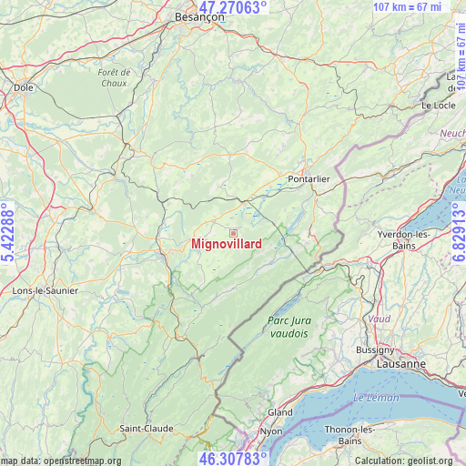
Mignovillard GPS coordinates[2]
46° 47' 28.968" North, 6° 7' 33.6" East
| Map corner | latitude | longitude |
|---|---|---|
| Upper-left | 47.27063°, | 5.42288° |
| Center: | 46.79138°, | 6.126° |
| Lower-right: | 46.30783°, | 6.82913° |
| Map W x H: | 107.1×107.1 km | = 66.5×66.5mi |
| max Lat: | 51.07786° ⇑57.3% North |
| Mignovillard: | 46.79138° |
| min Lat: | ⇓42.7% South 41.3874° |
| min Long | Mignovillard | max Long |
| -5.08615° | 6.126° | 9.52242° |
| W 88.5%⇐ | ⇒11.5% E |
Elevation
Elevation of Mignovillard is 865 m = 2838 ft, and this is 671.3 m = 2202 ft above average elevation for this country.
| Max E: |
2333 m = 7654 ft | 1.7% |
| Mignovillard | 865 m 2838 ft | |
| Avg. | 193.7 m = 635 ft | |
Min E: |
-1 m = -3 ft | 98.3% |
See also: France elevation on elevation.city.
Geographical zone
Mignovillard is located in North temperate zone (between Tropic of Cancer and the Arctic Circle). Distance of this North polar circle is 2198.5 km =1366.1 mi to North.| Distance of | km | miles | from Mignovillard |
|---|---|---|---|
| North Pole | 4804.3 | 2985.3 | to North |
| Arctic Circle | 2198.5 | 1366.1 | to North |
| Tropic Cancer | 2596.8 | 1613.6 | to South |
| Equator | 5202.7 | 3232.8 | to South |


Nearby cities:
15 places around Mignovillard: (largest is in red/bold)
• Andelot-en-Montagne
16.1 km =10 mi,  294°
294°
• Chaffois
17.5 km =10.9 mi,  39°
39°
• Champagnole
17 km =10.6 mi,  252°
252°
• Foncine-le-Haut
15.4 km =9.6 mi,  195°
195°
• Frasne
7.7 km =4.8 mi,  19°
19°
• La Rivière-Drugeon
11 km =6.8 mi, 39°
• Labergement-Sainte-Marie
11.8 km =7.3 mi,  99°
99°
• Malbuisson
13.5 km =8.4 mi,  87°
87°
• Montperreux
16.9 km =10.5 mi,  76°
76°
• Mouthe
10.5 km =6.5 mi,  152°
152°
• Métabief
17.5 km =10.9 mi, 97°
• Oye-et-Pallet
16.8 km =10.4 mi,  67°
67°
• Sirod
12.6 km =7.8 mi,  238°
238°
• Vaux-et-Chantegrue
9.3 km =5.8 mi, 78°
• Équevillon
14.6 km =9.1 mi,  256°
256°
Sources, notices
• [Note1] Compared only with cities in France existing in our database
• [Src1] Map data: © OpenStreetMap contributors (CC-BY-SA)
• [Src2] Other city data from geonames.org with taken over terms of usage.
• [Src3] Geographical zone / Annual Mean Temperature by Robert A. Rohde @ Wikipedia
