Champagnole geodata
Champagnole (Bourgogne-Franche-Comté) is a populated place; located in France in Europe/Paris (GMT+2) time zone. With population of 9,239 people, there are 1039 cities with bigger population in this country. Compared to other cities in France, 57.7% of cities are located further ↑North; 86.1% of cities are located further ←West and 93.9% of cities have lower elevation than Champagnole. Note1
Administrative division(s):
- Level 1: Bourgogne-Franche-Comté
- Level 2: Jura
- Level 3: Arrondissement de Lons-le-Saunier
- Level 4: Champagnole


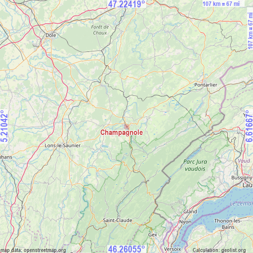
Champagnole GPS coordinates[2]
46° 44' 40.272" North, 5° 54' 48.744" East
| Map corner | latitude | longitude |
|---|---|---|
| Upper-left | 47.22419°, | 5.21042° |
| Center: | 46.74452°, | 5.91354° |
| Lower-right: | 46.26055°, | 6.61667° |
| Map W x H: | 107.1×107.1 km | = 66.5×66.5mi |
| max Lat: | 51.07786° ⇑57.7% North |
| Champagnole: | 46.74452° |
| min Lat: | ⇓42.3% South 41.3874° |
| min Long | Champagnole | max Long |
| -5.08615° | 5.91354° | 9.52242° |
| W 86.1%⇐ | ⇒13.9% E |
Elevation
Elevation of Champagnole is 540 m = 1772 ft, and this is 346.3 m = 1136 ft above average elevation for this country.
| Max E: |
2333 m = 7654 ft | 6.1% |
| Champagnole | 540 m 1772 ft | |
| Avg. | 193.7 m = 635 ft | |
Min E: |
-1 m = -3 ft | 93.9% |
See also: France elevation on elevation.city.
Geographical zone
Champagnole is located in North temperate zone (between Tropic of Cancer and the Arctic Circle). Distance of this North polar circle is 2203.7 km =1369.3 mi to North.| Distance of | km | miles | from Champagnole |
|---|---|---|---|
| North Pole | 4809.6 | 2988.5 | to North |
| Arctic Circle | 2203.7 | 1369.3 | to North |
| Tropic Cancer | 2591.6 | 1610.3 | to South |
| Equator | 5197.5 | 3229.6 | to South |


Nearby cities:
15 places around Champagnole: (largest is in red/bold)
• Andelot-en-Montagne
12.1 km =7.5 mi,  7°
7°
• Arbois
20.6 km =12.8 mi,  329°
329°
• Cize
2.3 km =1.4 mi,  169°
169°
• Crançot
20.4 km =12.7 mi,  251°
251°
• Crotenay
7.7 km =4.8 mi,  276°
276°
• Foncine-le-Haut
15.3 km =9.5 mi,  128°
128°
• La Chaux-du-Dombief
15.8 km =9.8 mi,  183°
183°
• Mesnay
19.2 km =11.9 mi, 333°
• Mignovillard
17 km =10.6 mi,  72°
72°
• Mouthe
21.4 km =13.3 mi,  101°
101°
• Ney
2.3 km =1.4 mi,  244°
244°
• Poligny
18.9 km =11.7 mi,  302°
302°
• Saint-Laurent-en-Grandvaux
18.1 km =11.2 mi, 171°
• Sirod
5.5 km =3.4 mi, 103°
• Équevillon
2.7 km =1.7 mi,  49°
49°
Sources, notices
• [Note1] Compared only with cities in France existing in our database
• [Src1] Map data: © OpenStreetMap contributors (CC-BY-SA)
• [Src2] Other city data from geonames.org with taken over terms of usage.
• [Src3] Geographical zone / Annual Mean Temperature by Robert A. Rohde @ Wikipedia
