Foncine-le-Haut geodata
Foncine-le-Haut (Bourgogne-Franche-Comté) is a populated place; located in France in Europe/Paris (GMT+2) time zone. With population of 977 people, there are 9003 cities with bigger population in this country. Compared to other cities in France, 58.7% of cities are located further ↑North; 87.8% of cities are located further ←West and 98.4% of cities have lower elevation than Foncine-le-Haut. Note1
Administrative division(s):
- Level 1: Bourgogne-Franche-Comté
- Level 2: Jura
- Level 3: Arrondissement de Lons-le-Saunier
- Level 4: Foncine-le-Haut


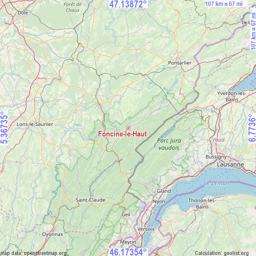
Foncine-le-Haut GPS coordinates[2]
46° 39' 29.808" North, 6° 4' 13.728" East
| Map corner | latitude | longitude |
|---|---|---|
| Upper-left | 47.13872°, | 5.36735° |
| Center: | 46.65828°, | 6.07048° |
| Lower-right: | 46.17354°, | 6.7736° |
| Map W x H: | 107.3×107.3 km | = 66.7×66.7mi |
| max Lat: | 51.07786° ⇑58.7% North |
| Foncine-le-Haut: | 46.65828° |
| min Lat: | ⇓41.3% South 41.3874° |
| min Long | Foncine-le-Haut | max Long |
| -5.08615° | 6.07048° | 9.52242° |
| W 87.8%⇐ | ⇒12.2% E |
Elevation
Elevation of Foncine-le-Haut is 872 m = 2861 ft, and this is 678.3 m = 2225 ft above average elevation for this country.
| Max E: |
2333 m = 7654 ft | 1.6% |
| Foncine-le-Haut | 872 m 2861 ft | |
| Avg. | 193.7 m = 635 ft | |
Min E: |
-1 m = -3 ft | 98.4% |
See also: France elevation on elevation.city.
Geographical zone
Foncine-le-Haut is located in North temperate zone (between Tropic of Cancer and the Arctic Circle). Distance of this North polar circle is 2213.3 km =1375.3 mi to North.| Distance of | km | miles | from Foncine-le-Haut |
|---|---|---|---|
| North Pole | 4819.1 | 2994.4 | to North |
| Arctic Circle | 2213.3 | 1375.3 | to North |
| Tropic Cancer | 2582 | 1604.4 | to South |
| Equator | 5187.9 | 3223.6 | to South |


Nearby cities:
15 places around Foncine-le-Haut: (largest is in red/bold)
• Bois-d’Amont
14.9 km =9.3 mi,  159°
159°
• Champagnole
15.3 km =9.5 mi,  308°
308°
• Cize
13.7 km =8.5 mi,  302°
302°
• La Chaux-du-Dombief
14.4 km =8.9 mi,  244°
244°
• Labergement-Sainte-Marie
20.5 km =12.7 mi,  50°
50°
• Les Rousses
19.4 km =12.1 mi,  181°
181°
• Mignovillard
15.4 km =9.6 mi,  15°
15°
• Morbier
14.1 km =8.8 mi,  197°
197°
• Morez
15.2 km =9.4 mi,  192°
192°
• Mouthe
10.5 km =6.5 mi,  58°
58°
• Ney
16.5 km =10.3 mi, 301°
• Saint-Laurent-en-Grandvaux
12.4 km =7.7 mi,  227°
227°
• Sirod
10.6 km =6.6 mi,  321°
321°
• Vaux-et-Chantegrue
21.3 km =13.2 mi,  38°
38°
• Équevillon
15.1 km =9.4 mi, 318°
Sources, notices
• [Note1] Compared only with cities in France existing in our database
• [Src1] Map data: © OpenStreetMap contributors (CC-BY-SA)
• [Src2] Other city data from geonames.org with taken over terms of usage.
• [Src3] Geographical zone / Annual Mean Temperature by Robert A. Rohde @ Wikipedia
