Mézières-en-Vexin geodata
Mézières-en-Vexin (Normandy) is a populated place; located in France in Europe/Paris (GMT+2) time zone. With population of 638 people, there are 12704 cities with bigger population in this country. Compared to other cities in France, 83.7% of cities are located further ↓South; 62.9% of cities are located further →East and 57.1% of cities have lower elevation than Mézières-en-Vexin. Note1
Administrative division(s):
- Level 1: Normandy
- Level 2: Département de l'Eure
- Level 3: Les Andelys
- Level 4: Mézières-en-Vexin


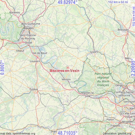
Mézières-en-Vexin GPS coordinates[2]
49° 10' 19.848" North, 1° 30' 13.788" East
| Map corner | latitude | longitude |
|---|---|---|
| Upper-left | 49.62974°, | 0.8007° |
| Center: | 49.17218°, | 1.50383° |
| Lower-right: | 48.71035°, | 2.20695° |
| Map W x H: | 102.2×102.2 km | = 63.5×63.5mi |
| max Lat: | 51.07786° ⇑16.3% North |
| Mézières-en-Vexin: | 49.17218° |
| min Lat: | ⇓83.7% South 41.3874° |
| min Long | Mézières-en-V | max Long |
| -5.08615° | 1.50383° | 9.52242° |
| W 37.1%⇐ | ⇒62.9% E |
Elevation
Elevation of Mézières-en-Vexin is 158 m = 518 ft, and this is 35.7 m = 117 ft below average elevation for this country.
| Max E: |
2333 m = 7654 ft | 42.9% |
| Avg. | 193.7 m = 635 ft | |
| Mézières-en-Vexin | 158 m = 518 ft | |
Min E: |
-1 m = -3 ft | 57.1% |
See also: France elevation on elevation.city.
Geographical zone
Mézières-en-Vexin is located in North temperate zone (between Tropic of Cancer and the Arctic Circle). Distance of this North polar circle is 1933.7 km =1201.5 mi to North.| Distance of | km | miles | from Mézières-en-Vexin |
|---|---|---|---|
| North Pole | 4539.6 | 2820.8 | to North |
| Arctic Circle | 1933.7 | 1201.5 | to North |
| Tropic Cancer | 2861.5 | 1778.1 | to South |
| Equator | 5467.4 | 3397.3 | to South |


Nearby cities:
15 places around Mézières-en-Vexin: (largest is in red/bold)
• Bois-Jérôme-Saint-Ouen
7.9 km =4.9 mi,  163°
163°
• Bouafles
9.6 km =6 mi,  298°
298°
• Courcelles-sur-Seine
10.5 km =6.5 mi,  276°
276°
• Hennezis
3.7 km =2.3 mi,  309°
309°
• Les Thilliers-en-Vexin
10.3 km =6.4 mi,  45°
45°
• Port-Mort
6.5 km =4 mi,  262°
262°
• Pressagny-le-Val
4.5 km =2.8 mi, 256°
• Saint-Just
8.4 km =5.2 mi,  212°
212°
• Saint-Marcel
8.9 km =5.5 mi, 206°
• Saint-Pierre-de-Bailleul
9.8 km =6.1 mi,  236°
236°
• Saint-Pierre-la-Garenne
8.3 km =5.2 mi,  249°
249°
• Tilly
3.5 km =2.2 mi,  149°
149°
• Tourny
3.2 km =2 mi,  69°
69°
• Vernon
9.3 km =5.8 mi,  198°
198°
• Écos
10.6 km =6.6 mi,  93°
93°
Sources, notices
• [Note1] Compared only with cities in France existing in our database
• [Src1] Map data: © OpenStreetMap contributors (CC-BY-SA)
• [Src2] Other city data from geonames.org with taken over terms of usage.
• [Src3] Geographical zone / Annual Mean Temperature by Robert A. Rohde @ Wikipedia
