Courcelles-sur-Seine geodata
Courcelles-sur-Seine (Normandy) is a populated place; located in France in Europe/Paris (GMT+2) time zone. With population of 1,601 people, there are 5828 cities with bigger population in this country. Compared to other cities in France, 84% of cities are located further ↓South; 64.9% of cities are located further →East and 91.2% of cities have higher elevation than Courcelles-sur-Seine. Note1
Administrative division(s):
- Level 1: Normandy
- Level 2: Département de l'Eure
- Level 3: Les Andelys
- Level 4: Courcelles-sur-Seine


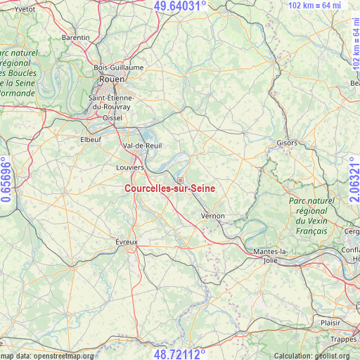
Courcelles-sur-Seine GPS coordinates[2]
49° 10' 58.26" North, 1° 21' 36.288" East
| Map corner | latitude | longitude |
|---|---|---|
| Upper-left | 49.64031°, | 0.65696° |
| Center: | 49.18285°, | 1.36008° |
| Lower-right: | 48.72112°, | 2.06321° |
| Map W x H: | 102.2×102.2 km | = 63.5×63.5mi |
| max Lat: | 51.07786° ⇑16% North |
| Courcelles-sur-Seine: | 49.18285° |
| min Lat: | ⇓84% South 41.3874° |
| min Long | Courcelles-sur- | max Long |
| -5.08615° | 1.36008° | 9.52242° |
| W 35.1%⇐ | ⇒64.9% E |
Elevation
Elevation of Courcelles-sur-Seine is 27 m = 89 ft, and this is 166.7 m = 547 ft below average elevation for this country.
| Max E: |
2333 m = 7654 ft | 91.2% |
| Avg. | 193.7 m = 635 ft | |
| Courcelles-sur-Seine | 27 m = 89 ft | |
Min E: |
-1 m = -3 ft | 8.8% |
See also: France elevation on elevation.city.
Geographical zone
Courcelles-sur-Seine is located in North temperate zone (between Tropic of Cancer and the Arctic Circle). Distance of this North polar circle is 1932.6 km =1200.9 mi to North.| Distance of | km | miles | from Courcelles-sur-Seine |
|---|---|---|---|
| North Pole | 4538.4 | 2820 | to North |
| Arctic Circle | 1932.6 | 1200.9 | to North |
| Tropic Cancer | 2862.7 | 1778.8 | to South |
| Equator | 5468.6 | 3398 | to South |


Nearby cities:
15 places around Courcelles-sur-Seine: (largest is in red/bold)
• Aubevoye
2.2 km =1.4 mi,  233°
233°
• Bouafles
3.9 km =2.4 mi,  31°
31°
• Fontaine-Bellenger
7.2 km =4.5 mi,  272°
272°
• Gaillon
2.8 km =1.7 mi,  210°
210°
• Hennezis
7.7 km =4.8 mi,  81°
81°
• Les Andelys
7.9 km =4.9 mi, 28°
• Muids
6.8 km =4.2 mi,  311°
311°
• Port-Mort
4.5 km =2.8 mi,  116°
116°
• Pressagny-le-Val
6.5 km =4 mi,  110°
110°
• Saint-Aubin-sur-Gaillon
4.6 km =2.9 mi, 209°
• Saint-Pierre-de-Bailleul
7 km =4.3 mi,  160°
160°
• Saint-Pierre-la-Garenne
4.8 km =3 mi,  146°
146°
• Tosny
4.1 km =2.5 mi,  13°
13°
• Venables
5.1 km =3.2 mi,  290°
290°
• Villers-sur-le-Roule
2.9 km =1.8 mi,  301°
301°
Sources, notices
• [Note1] Compared only with cities in France existing in our database
• [Src1] Map data: © OpenStreetMap contributors (CC-BY-SA)
• [Src2] Other city data from geonames.org with taken over terms of usage.
• [Src3] Geographical zone / Annual Mean Temperature by Robert A. Rohde @ Wikipedia
