Meys geodata
Meys (Auvergne-Rhône-Alpes) is a populated place; located in France in Europe/Paris (GMT+2) time zone. With population of 677 people, there are 12108 cities with bigger population in this country. Compared to other cities in France, 71.2% of cities are located further ↑North; 71.3% of cities are located further ←West and 94.6% of cities have lower elevation than Meys. Note1
Administrative division(s):
- Level 1: Auvergne-Rhône-Alpes
- Level 2: Département du Rhône
- Level 3: Arrondissement de Lyon
- Level 4: Meys


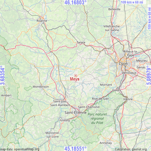
Meys GPS coordinates[2]
45° 40' 44.148" North, 4° 23' 11.976" East
| Map corner | latitude | longitude |
|---|---|---|
| Upper-left | 46.16803°, | 3.68354° |
| Center: | 45.67893°, | 4.38666° |
| Lower-right: | 45.18551°, | 5.08979° |
| Map W x H: | 109.2×109.2 km | = 67.9×67.9mi |
| max Lat: | 51.07786° ⇑71.2% North |
| Meys: | 45.67893° |
| min Lat: | ⇓28.8% South 41.3874° |
| min Long | Meys | max Long |
| -5.08615° | 4.38666° | 9.52242° |
| W 71.3%⇐ | ⇒28.7% E |
Elevation
Elevation of Meys is 564 m = 1850 ft, and this is 370.3 m = 1215 ft above average elevation for this country.
| Max E: |
2333 m = 7654 ft | 5.4% |
| Meys | 564 m 1850 ft | |
| Avg. | 193.7 m = 635 ft | |
Min E: |
-1 m = -3 ft | 94.6% |
See also: France elevation on elevation.city.
Geographical zone
Meys is located in North temperate zone (between Tropic of Cancer and the Arctic Circle). Distance of this North polar circle is 2322.2 km =1442.9 mi to North.| Distance of | km | miles | from Meys |
|---|---|---|---|
| North Pole | 4928 | 3062.1 | to North |
| Arctic Circle | 2322.2 | 1442.9 | to North |
| Tropic Cancer | 2473.1 | 1536.7 | to South |
| Equator | 5079 | 3155.9 | to South |


Nearby cities:
15 places around Meys: (largest is in red/bold)
• Aveize
7.1 km =4.4 mi,  86°
86°
• Bellegarde-en-Forez
7.9 km =4.9 mi,  241°
241°
• Chazelles-sur-Lyon
4.6 km =2.9 mi,  177°
177°
• Grézieu-le-Marché
3.7 km =2.3 mi,  133°
133°
• Haute-Rivoire
4.1 km =2.5 mi,  10°
10°
• Maringes
3.4 km =2.1 mi, 235°
• Pomeys
5.5 km =3.4 mi, 126°
• Saint-Barthélemy-Lestra
5.7 km =3.5 mi,  320°
320°
• Saint-Cyr-les-Vignes
7.1 km =4.4 mi,  261°
261°
• Saint-Denis-sur-Coise
7.8 km =4.8 mi,  157°
157°
• Saint-Martin-Lestra
5.2 km =3.2 mi,  331°
331°
• Saint-Symphorien-sur-Coise
7.5 km =4.7 mi, 133°
• Sainte-Foy-l’Argentière
7.3 km =4.5 mi,  63°
63°
• Souzy
5.7 km =3.5 mi, 58°
• Valeille
7.3 km =4.5 mi,  296°
296°
Sources, notices
• [Note1] Compared only with cities in France existing in our database
• [Src1] Map data: © OpenStreetMap contributors (CC-BY-SA)
• [Src2] Other city data from geonames.org with taken over terms of usage.
• [Src3] Geographical zone / Annual Mean Temperature by Robert A. Rohde @ Wikipedia
