Saint-Barthélemy-Lestra geodata
Saint-Barthélemy-Lestra (Auvergne-Rhône-Alpes) is a populated place; located in France in Europe/Paris (GMT+2) time zone. With population of 601 people, there are 13304 cities with bigger population in this country. Compared to other cities in France, 70.6% of cities are located further ↑North; 70.9% of cities are located further ←West and 93.9% of cities have lower elevation than Saint-Barthélemy-Lestra. Note1
Administrative division(s):
- Level 1: Auvergne-Rhône-Alpes
- Level 2: Département de la Loire
- Level 3: Arrondissement de Montbrison
- Level 4: Saint-Barthélemy-Lestra
Current local time in Saint-Barthélemy-Lestra:
12:41 PM, SaturdayDifference from your time zone: hours


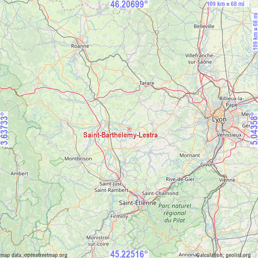
Saint-Barthélemy-Lestra GPS coordinates[2]
45° 43' 5.628" North, 4° 20' 25.62" East
| Map corner | latitude | longitude |
|---|---|---|
| Upper-left | 46.20699°, | 3.63733° |
| Center: | 45.71823°, | 4.34045° |
| Lower-right: | 45.22516°, | 5.04358° |
| Map W x H: | 109.2×109.2 km | = 67.9×67.9mi |
| max Lat: | 51.07786° ⇑70.6% North |
| Saint-Barthélemy-Lestra: | 45.71823° |
| min Lat: | ⇓29.4% South 41.3874° |
| min Long | Saint-Barthéle | max Long |
| -5.08615° | 4.34045° | 9.52242° |
| W 70.9%⇐ | ⇒29.1% E |
Elevation
Elevation of Saint-Barthélemy-Lestra is 538 m = 1765 ft, and this is 344.3 m = 1130 ft above average elevation for this country.
| Max E: |
2333 m = 7654 ft | 6.1% |
| Saint-Barthélemy-Lestra | 538 m 1765 ft | |
| Avg. | 193.7 m = 635 ft | |
Min E: |
-1 m = -3 ft | 93.9% |
See also: France elevation on elevation.city.
Geographical zone
Saint-Barthélemy-Lestra is located in North temperate zone (between Tropic of Cancer and the Arctic Circle). Distance of this North polar circle is 2317.8 km =1440.2 mi to North.| Distance of | km | miles | from Saint-Barthélemy-Lestra |
|---|---|---|---|
| North Pole | 4923.7 | 3059.4 | to North |
| Arctic Circle | 2317.8 | 1440.2 | to North |
| Tropic Cancer | 2477.5 | 1539.4 | to South |
| Equator | 5083.4 | 3158.7 | to South |


Nearby cities:
15 places around Saint-Barthélemy-Lestra: (largest is in red/bold)
• Bellegarde-en-Forez
8.8 km =5.5 mi,  202°
202°
• Chambost-Longessaigne
6.5 km =4 mi,  20°
20°
• Chazelles-sur-Lyon
9.7 km =6 mi,  157°
157°
• Cottance
8.9 km =5.5 mi,  339°
339°
• Feurs
8.9 km =5.5 mi,  280°
280°
• Grézieu-le-Marché
9.3 km =5.8 mi,  137°
137°
• Haute-Rivoire
4.3 km =2.7 mi,  93°
93°
• Maringes
6.4 km =4 mi,  173°
173°
• Meys
5.7 km =3.5 mi, 140°
• Panissières
8.2 km =5.1 mi,  0°
0°
• Saint-Clément-les-Places
7.5 km =4.7 mi,  59°
59°
• Saint-Cyr-les-Vignes
6.3 km =3.9 mi,  212°
212°
• Saint-Martin-Lestra
1.1 km =0.7 mi,  79°
79°
• Souzy
8.5 km =5.3 mi,  99°
99°
• Valeille
3.1 km =1.9 mi,  249°
249°
Sources, notices
• [Note1] Compared only with cities in France existing in our database
• [Src1] Map data: © OpenStreetMap contributors (CC-BY-SA)
• [Src2] Other city data from geonames.org with taken over terms of usage.
• [Src3] Geographical zone / Annual Mean Temperature by Robert A. Rohde @ Wikipedia
