Messein geodata
Messein (Grand Est) is a populated place; located in France in Europe/Paris (GMT+2) time zone. With population of 1,532 people, there are 6076 cities with bigger population in this country. Compared to other cities in France, 71.2% of cities are located further ↓South; 88.7% of cities are located further ←West and 76.2% of cities have lower elevation than Messein. Note1
Administrative division(s):
- Level 1: Grand Est
- Level 2: Meurthe-et-Moselle
- Level 3: Arrondissement de Nancy
- Level 4: Messein


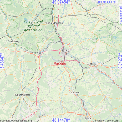
Messein GPS coordinates[2]
48° 36' 42.48" North, 6° 8' 22.524" East
| Map corner | latitude | longitude |
|---|---|---|
| Upper-left | 49.07454°, | 5.43647° |
| Center: | 48.6118°, | 6.13959° |
| Lower-right: | 48.14478°, | 6.84272° |
| Map W x H: | 103.4×103.4 km | = 64.2×64.2mi |
| max Lat: | 51.07786° ⇑28.8% North |
| Messein: | 48.6118° |
| min Lat: | ⇓71.2% South 41.3874° |
| min Long | Messein | max Long |
| -5.08615° | 6.13959° | 9.52242° |
| W 88.7%⇐ | ⇒11.3% E |
Elevation
Elevation of Messein is 258 m = 846 ft, and this is 64.3 m = 211 ft above average elevation for this country.
| Max E: |
2333 m = 7654 ft | 23.8% |
| Messein | 258 m 846 ft | |
| Avg. | 193.7 m = 635 ft | |
Min E: |
-1 m = -3 ft | 76.2% |
See also: France elevation on elevation.city.
Geographical zone
Messein is located in North temperate zone (between Tropic of Cancer and the Arctic Circle). Distance of this North polar circle is 1996 km =1240.3 mi to North.| Distance of | km | miles | from Messein |
|---|---|---|---|
| North Pole | 4601.9 | 2859.5 | to North |
| Arctic Circle | 1996 | 1240.3 | to North |
| Tropic Cancer | 2799.2 | 1739.3 | to South |
| Equator | 5405.1 | 3358.6 | to South |


Nearby cities:
15 places around Messein: (largest is in red/bold)
• Bainville-sur-Madon
4.2 km =2.6 mi,  229°
229°
• Chaligny
4.4 km =2.7 mi,  288°
288°
• Chavigny
2.3 km =1.4 mi,  327°
327°
• Flavigny-sur-Moselle
6.3 km =3.9 mi,  144°
144°
• Fléville-devant-Nancy
4.9 km =3 mi,  72°
72°
• Frolois
5.3 km =3.3 mi,  190°
190°
• Heillecourt
5.9 km =3.7 mi,  43°
43°
• Houdemont
4.5 km =2.8 mi, 36°
• Ludres
2.3 km =1.4 mi, 65°
• Méréville
2.4 km =1.5 mi,  159°
159°
• Neuves-Maisons
2.6 km =1.6 mi, 285°
• Pont-Saint-Vincent
3.1 km =1.9 mi,  256°
256°
• Richardménil
3 km =1.9 mi,  133°
133°
• Vandœuvre-lès-Nancy
5.3 km =3.3 mi, 37°
• Xeuilley
5.8 km =3.6 mi,  211°
211°
Sources, notices
• [Note1] Compared only with cities in France existing in our database
• [Src1] Map data: © OpenStreetMap contributors (CC-BY-SA)
• [Src2] Other city data from geonames.org with taken over terms of usage.
• [Src3] Geographical zone / Annual Mean Temperature by Robert A. Rohde @ Wikipedia
