Vandœuvre-lès-Nancy geodata
Vandœuvre-lès-Nancy (Grand Est) is a populated place; located in France in Europe/Paris (GMT+2) time zone. With population of 31,785 people, there are 250 cities with bigger population in this country. Compared to other cities in France, 72.1% of cities are located further ↓South; 89.1% of cities are located further ←West and 73.5% of cities have lower elevation than Vandœuvre-lès-Nancy. Note1
Administrative division(s):
- Level 1: Grand Est
- Level 2: Meurthe-et-Moselle
- Level 3: Arrondissement de Nancy
- Level 4: Vandœuvre-lès-Nancy


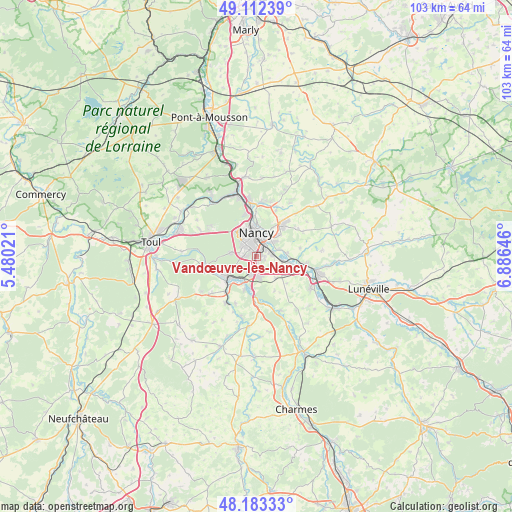
Vandœuvre-lès-Nancy GPS coordinates[2]
48° 39' 0" North, 6° 10' 59.988" East
| Map corner | latitude | longitude |
|---|---|---|
| Upper-left | 49.11239°, | 5.48021° |
| Center: | 48.65°, | 6.18333° |
| Lower-right: | 48.18333°, | 6.88646° |
| Map W x H: | 103.3×103.3 km | = 64.2×64.2mi |
| max Lat: | 51.07786° ⇑27.9% North |
| Vandœuvre-lès-Nancy: | 48.65° |
| min Lat: | ⇓72.1% South 41.3874° |
| min Long | Vandœuvre-lès | max Long |
| -5.08615° | 6.18333° | 9.52242° |
| W 89.1%⇐ | ⇒10.9% E |
Elevation
Elevation of Vandœuvre-lès-Nancy is 239 m = 784 ft, and this is 45.3 m = 149 ft above average elevation for this country.
| Max E: |
2333 m = 7654 ft | 26.5% |
| Vandœuvre-lès-Nancy | 239 m 784 ft | |
| Avg. | 193.7 m = 635 ft | |
Min E: |
-1 m = -3 ft | 73.5% |
See also: France elevation on elevation.city.
Geographical zone
Vandœuvre-lès-Nancy is located in North temperate zone (between Tropic of Cancer and the Arctic Circle). Distance of this North polar circle is 1991.8 km =1237.6 mi to North.| Distance of | km | miles | from Vandœuvre-lès-Nancy |
|---|---|---|---|
| North Pole | 4597.7 | 2856.9 | to North |
| Arctic Circle | 1991.8 | 1237.6 | to North |
| Tropic Cancer | 2803.5 | 1742 | to South |
| Equator | 5409.4 | 3361.2 | to South |


Nearby cities:
15 places around Vandœuvre-lès-Nancy: (largest is in red/bold)
• Art-sur-Meurthe
6.2 km =3.9 mi,  82°
82°
• Chavigny
5 km =3.1 mi,  242°
242°
• Fléville-devant-Nancy
3.1 km =1.9 mi,  152°
152°
• Heillecourt
0.9 km =0.6 mi,  86°
86°
• Houdemont
0.9 km =0.6 mi,  220°
220°
• Jarville-la-Malgrange
2.4 km =1.5 mi,  37°
37°
• Laneuveville-devant-Nancy
3.3 km =2.1 mi, 77°
• Laxou
4.5 km =2.8 mi,  326°
326°
• Ludres
3.5 km =2.2 mi,  199°
199°
• Messein
5.3 km =3.3 mi, 217°
• Nancy
3.8 km =2.4 mi,  1°
1°
• Saint-Max
6.3 km =3.9 mi,  15°
15°
• Saulxures-lès-Nancy
6.2 km =3.9 mi,  45°
45°
• Tomblaine
4.5 km =2.8 mi,  32°
32°
• Villers-lès-Nancy
3.4 km =2.1 mi,  319°
319°
Sources, notices
• [Note1] Compared only with cities in France existing in our database
• [Src1] Map data: © OpenStreetMap contributors (CC-BY-SA)
• [Src2] Other city data from geonames.org with taken over terms of usage.
• [Src3] Geographical zone / Annual Mean Temperature by Robert A. Rohde @ Wikipedia
