Frolois geodata
Frolois (Grand Est) is a populated place; located in France in Europe/Paris (GMT+2) time zone. With population of 576 people, there are 13727 cities with bigger population in this country. Compared to other cities in France, 69.9% of cities are located further ↓South; 88.5% of cities are located further ←West and 80.1% of cities have lower elevation than Frolois. Note1
Administrative division(s):
- Level 1: Grand Est
- Level 2: Meurthe-et-Moselle
- Level 3: Arrondissement de Nancy
- Level 4: Frolois


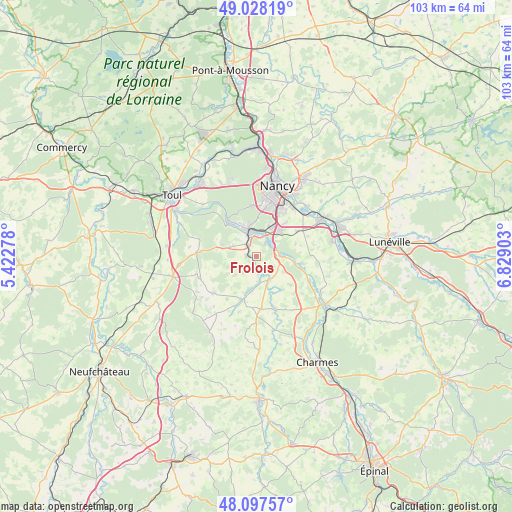
Frolois GPS coordinates[2]
48° 33' 54.072" North, 6° 7' 33.24" East
| Map corner | latitude | longitude |
|---|---|---|
| Upper-left | 49.02819°, | 5.42278° |
| Center: | 48.56502°, | 6.1259° |
| Lower-right: | 48.09757°, | 6.82903° |
| Map W x H: | 103.5×103.5 km | = 64.3×64.3mi |
| max Lat: | 51.07786° ⇑30.1% North |
| Frolois: | 48.56502° |
| min Lat: | ⇓69.9% South 41.3874° |
| min Long | Frolois | max Long |
| -5.08615° | 6.1259° | 9.52242° |
| W 88.5%⇐ | ⇒11.5% E |
Elevation
Elevation of Frolois is 291 m = 955 ft, and this is 97.3 m = 319 ft above average elevation for this country.
| Max E: |
2333 m = 7654 ft | 19.9% |
| Frolois | 291 m 955 ft | |
| Avg. | 193.7 m = 635 ft | |
Min E: |
-1 m = -3 ft | 80.1% |
See also: France elevation on elevation.city.
Geographical zone
Frolois is located in North temperate zone (between Tropic of Cancer and the Arctic Circle). Distance of this North polar circle is 2001.3 km =1243.5 mi to North.| Distance of | km | miles | from Frolois |
|---|---|---|---|
| North Pole | 4607.1 | 2862.7 | to North |
| Arctic Circle | 2001.3 | 1243.5 | to North |
| Tropic Cancer | 2794 | 1736.1 | to South |
| Equator | 5399.9 | 3355.3 | to South |


Nearby cities:
15 places around Frolois: (largest is in red/bold)
• Bainville-sur-Madon
3.3 km =2.1 mi,  318°
318°
• Ceintrey
5.3 km =3.3 mi,  148°
148°
• Chaligny
7.3 km =4.5 mi,  334°
334°
• Chavigny
7.1 km =4.4 mi,  358°
358°
• Flavigny-sur-Moselle
4.6 km =2.9 mi,  89°
89°
• Ludres
6.9 km =4.3 mi,  26°
26°
• Maizières
5.3 km =3.3 mi,  292°
292°
• Messein
5.3 km =3.3 mi,  10°
10°
• Méréville
3.4 km =2.1 mi, 32°
• Neuves-Maisons
6.1 km =3.8 mi,  345°
345°
• Pont-Saint-Vincent
4.9 km =3 mi,  335°
335°
• Pulligny
3.2 km =2 mi,  155°
155°
• Richardménil
4.5 km =2.8 mi,  45°
45°
• Viterne
7.5 km =4.7 mi, 289°
• Xeuilley
2 km =1.2 mi,  275°
275°
Sources, notices
• [Note1] Compared only with cities in France existing in our database
• [Src1] Map data: © OpenStreetMap contributors (CC-BY-SA)
• [Src2] Other city data from geonames.org with taken over terms of usage.
• [Src3] Geographical zone / Annual Mean Temperature by Robert A. Rohde @ Wikipedia
