Méaudre geodata
Méaudre (Auvergne-Rhône-Alpes) is a populated place; located in France in Europe/Paris (GMT+2) time zone. With population of 1,200 people, there are 7535 cities with bigger population in this country. Compared to other cities in France, 78.2% of cities are located further ↑North; 83.1% of cities are located further ←West and 99% of cities have lower elevation than Méaudre. Note1
Administrative division(s):
- Level 1: Auvergne-Rhône-Alpes
- Level 2: Département de l'Isère
- Level 3: Arrondissement de Grenoble
- Level 4: Autrans-Méaudre en Vercors


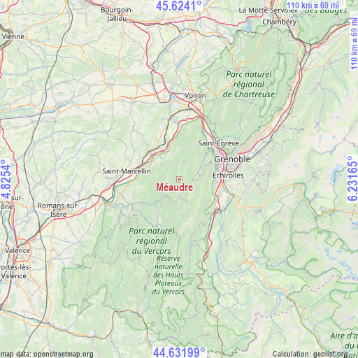
Méaudre GPS coordinates[2]
45° 7' 48.72" North, 5° 31' 42.708" East
| Map corner | latitude | longitude |
|---|---|---|
| Upper-left | 45.6241°, | 4.8254° |
| Center: | 45.1302°, | 5.52853° |
| Lower-right: | 44.63199°, | 6.23165° |
| Map W x H: | 110.3×110.3 km | = 68.5×68.5mi |
| max Lat: | 51.07786° ⇑78.2% North |
| Méaudre: | 45.1302° |
| min Lat: | ⇓21.8% South 41.3874° |
| min Long | Méaudre | max Long |
| -5.08615° | 5.52853° | 9.52242° |
| W 83.1%⇐ | ⇒16.9% E |
Elevation
Elevation of Méaudre is 988 m = 3241 ft, and this is 794.3 m = 2606 ft above average elevation for this country.
| Max E: |
2333 m = 7654 ft | 1% |
| Méaudre | 988 m 3241 ft | |
| Avg. | 193.7 m = 635 ft | |
Min E: |
-1 m = -3 ft | 99% |
See also: France elevation on elevation.city.
Geographical zone
Méaudre is located in North temperate zone (between Tropic of Cancer and the Arctic Circle). Distance of this North polar circle is 2383.2 km =1480.9 mi to North.| Distance of | km | miles | from Méaudre |
|---|---|---|---|
| North Pole | 4989.1 | 3100.1 | to North |
| Arctic Circle | 2383.2 | 1480.9 | to North |
| Tropic Cancer | 2412.1 | 1498.8 | to South |
| Equator | 5018 | 3118 | to South |


Nearby cities:
15 places around Méaudre: (largest is in red/bold)
• Allières-et-Risset
12.3 km =7.6 mi,  106°
106°
• Autrans
5.2 km =3.2 mi,  12°
12°
• Beaulieu
11.8 km =7.3 mi,  297°
297°
• Claix
11.4 km =7.1 mi,  95°
95°
• Cognin-les-Gorges
10.2 km =6.3 mi, 296°
• Izeron
12.3 km =7.6 mi,  277°
277°
• La Rivière
11.9 km =7.4 mi,  351°
351°
• Lans-en-Vercors
4.5 km =2.8 mi,  92°
92°
• Rovon
9.4 km =5.8 mi,  324°
324°
• Saint-Nizier-du-Moucherotte
9.2 km =5.7 mi,  60°
60°
• Saint-Paul-de-Varces
11.1 km =6.9 mi,  126°
126°
• Seyssins
12.9 km =8 mi,  73°
73°
• Têche
13.2 km =8.2 mi, 295°
• Villard-de-Lans
6.9 km =4.3 mi,  161°
161°
• Vinay
12.9 km =8 mi,  312°
312°
Sources, notices
• [Note1] Compared only with cities in France existing in our database
• [Src1] Map data: © OpenStreetMap contributors (CC-BY-SA)
• [Src2] Other city data from geonames.org with taken over terms of usage.
• [Src3] Geographical zone / Annual Mean Temperature by Robert A. Rohde @ Wikipedia
