Martignas-sur-Jalle geodata
Martignas-sur-Jalle (Nouvelle-Aquitaine) is a populated place; located in France in Europe/Paris (GMT+2) time zone. With population of 6,803 people, there are 1455 cities with bigger population in this country. Compared to other cities in France, 81% of cities are located further ↑North; 86.3% of cities are located further →East and 85.9% of cities have higher elevation than Martignas-sur-Jalle. Note1
Administrative division(s):
- Level 1: Nouvelle-Aquitaine
- Level 2: Gironde
- Level 3: Arrondissement de Bordeaux
- Level 4: Martignas-sur-Jalle


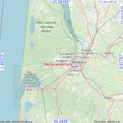
Martignas-sur-Jalle GPS coordinates[2]
44° 50' 43.008" North, 0° 46' 50.16" West
| Map corner | latitude | longitude |
|---|---|---|
| Upper-left | 45.34165°, | -1.48372° |
| Center: | 44.84528°, | -0.7806° |
| Lower-right: | 44.3446°, | -0.07747° |
| Map W x H: | 110.9×110.9 km | = 68.9×68.9mi |
| max Lat: | 51.07786° ⇑81% North |
| Martignas-sur-Jalle: | 44.84528° |
| min Lat: | ⇓19% South 41.3874° |
| min Long | Martignas-sur-J | max Long |
| -5.08615° | -0.7806° | 9.52242° |
| W 13.7%⇐ | ⇒86.3% E |
Elevation
Elevation of Martignas-sur-Jalle is 40 m = 131 ft, and this is 153.7 m = 504 ft below average elevation for this country.
| Max E: |
2333 m = 7654 ft | 85.9% |
| Avg. | 193.7 m = 635 ft | |
| Martignas-sur-Jalle | 40 m = 131 ft | |
Min E: |
-1 m = -3 ft | 14.1% |
See also: France elevation on elevation.city.
Geographical zone
Martignas-sur-Jalle is located in North temperate zone (between Tropic of Cancer and the Arctic Circle). Distance of this Northern Tropic circle is 2380.4 km =1479.1 mi to South.| Distance of | km | miles | from Martignas-sur-Jalle |
|---|---|---|---|
| North Pole | 5020.7 | 3119.7 | to North |
| Arctic Circle | 2414.8 | 1500.5 | to North |
| Tropic Cancer | 2380.4 | 1479.1 | to South |
| Equator | 4986.3 | 3098.3 | to South |


Nearby cities:
15 places around Martignas-sur-Jalle: (largest is in red/bold)
• Blanquefort
13.6 km =8.5 mi,  56°
56°
• Bruges
13.8 km =8.6 mi,  73°
73°
• Canéjan
14.5 km =9 mi,  126°
126°
• Cestas
13.9 km =8.6 mi,  144°
144°
• Eysines
11.4 km =7.1 mi, 68°
• Le Bouscat
14.9 km =9.3 mi,  81°
81°
• Le Haillan
8.5 km =5.3 mi, 69°
• Le Taillan-Médoc
10.9 km =6.8 mi,  52°
52°
• Mérignac
11.7 km =7.3 mi,  97°
97°
• Pessac
11.7 km =7.3 mi,  109°
109°
• Saint-Aubin-de-Médoc
8.6 km =5.3 mi,  30°
30°
• Saint-Jean-d’Illac
4.1 km =2.5 mi,  185°
185°
• Saint-Médard-en-Jalles
7.4 km =4.6 mi,  39°
39°
• Salaunes
10.9 km =6.8 mi,  338°
338°
• Talence
15.3 km =9.5 mi, 107°
Sources, notices
• [Note1] Compared only with cities in France existing in our database
• [Src1] Map data: © OpenStreetMap contributors (CC-BY-SA)
• [Src2] Other city data from geonames.org with taken over terms of usage.
• [Src3] Geographical zone / Annual Mean Temperature by Robert A. Rohde @ Wikipedia
