Saint-Jean-d’Illac geodata
Saint-Jean-d’Illac (Nouvelle-Aquitaine) is a populated place; located in France in Europe/Paris (GMT+2) time zone. With population of 6,826 people, there are 1447 cities with bigger population in this country. Compared to other cities in France, 81.3% of cities are located further ↑North; 86.3% of cities are located further →East and 83.1% of cities have higher elevation than Saint-Jean-d’Illac. Note1
Administrative division(s):
- Level 1: Nouvelle-Aquitaine
- Level 2: Gironde
- Level 3: Arrondissement de Bordeaux
- Level 4: Saint-Jean-d'Illac


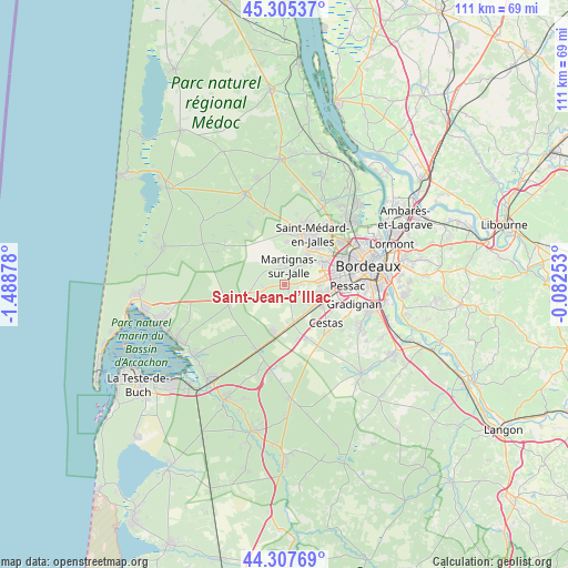
Saint-Jean-d’Illac GPS coordinates[2]
44° 48' 31.284" North, 0° 47' 8.34" West
| Map corner | latitude | longitude |
|---|---|---|
| Upper-left | 45.30537°, | -1.48878° |
| Center: | 44.80869°, | -0.78565° |
| Lower-right: | 44.30769°, | -0.08253° |
| Map W x H: | 110.9×110.9 km | = 68.9×68.9mi |
| max Lat: | 51.07786° ⇑81.3% North |
| Saint-Jean-d’Illac: | 44.80869° |
| min Lat: | ⇓18.7% South 41.3874° |
| min Long | Saint-Jean-d’ | max Long |
| -5.08615° | -0.78565° | 9.52242° |
| W 13.7%⇐ | ⇒86.3% E |
Elevation
Elevation of Saint-Jean-d’Illac is 47 m = 154 ft, and this is 146.7 m = 481 ft below average elevation for this country.
| Max E: |
2333 m = 7654 ft | 83.1% |
| Avg. | 193.7 m = 635 ft | |
| Saint-Jean-d’Illac | 47 m = 154 ft | |
Min E: |
-1 m = -3 ft | 16.9% |
See also: France elevation on elevation.city.
Geographical zone
Saint-Jean-d’Illac is located in North temperate zone (between Tropic of Cancer and the Arctic Circle). Distance of this Northern Tropic circle is 2376.3 km =1476.6 mi to South.| Distance of | km | miles | from Saint-Jean-d’Illac |
|---|---|---|---|
| North Pole | 5024.8 | 3122.3 | to North |
| Arctic Circle | 2418.9 | 1503 | to North |
| Tropic Cancer | 2376.3 | 1476.6 | to South |
| Equator | 4982.3 | 3095.9 | to South |


Nearby cities:
15 places around Saint-Jean-d’Illac: (largest is in red/bold)
• Bruges
15.8 km =9.8 mi,  59°
59°
• Canéjan
12.9 km =8 mi,  111°
111°
• Cestas
11.1 km =6.9 mi,  130°
130°
• Eysines
13.7 km =8.5 mi,  52°
52°
• Gradignan
14.1 km =8.8 mi, 106°
• Le Haillan
10.9 km =6.8 mi, 49°
• Le Taillan-Médoc
14.1 km =8.8 mi,  40°
40°
• Marcheprime
14.1 km =8.8 mi,  202°
202°
• Martignas-sur-Jalle
4.1 km =2.5 mi,  5°
5°
• Mérignac
12.3 km =7.6 mi,  77°
77°
• Pessac
11.4 km =7.1 mi,  89°
89°
• Saint-Aubin-de-Médoc
12.4 km =7.7 mi,  22°
22°
• Saint-Médard-en-Jalles
11 km =6.8 mi,  27°
27°
• Salaunes
14.6 km =9.1 mi,  345°
345°
• Talence
15 km =9.3 mi, 91°
Sources, notices
• [Note1] Compared only with cities in France existing in our database
• [Src1] Map data: © OpenStreetMap contributors (CC-BY-SA)
• [Src2] Other city data from geonames.org with taken over terms of usage.
• [Src3] Geographical zone / Annual Mean Temperature by Robert A. Rohde @ Wikipedia
