Canéjan geodata
Canéjan (Nouvelle-Aquitaine) is a populated place; located in France in Europe/Paris (GMT+2) time zone. With population of 5,513 people, there are 1797 cities with bigger population in this country. Compared to other cities in France, 81.6% of cities are located further ↑North; 84.8% of cities are located further →East and 85.9% of cities have higher elevation than Canéjan. Note1
Administrative division(s):
- Level 1: Nouvelle-Aquitaine
- Level 2: Gironde
- Level 3: Arrondissement de Bordeaux
- Level 4: Canéjan


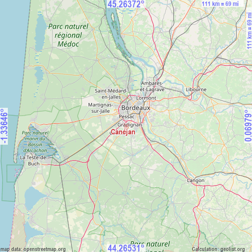
Canéjan GPS coordinates[2]
44° 46' 0.012" North, 0° 37' 59.988" West
| Map corner | latitude | longitude |
|---|---|---|
| Upper-left | 45.26372°, | -1.33646° |
| Center: | 44.76667°, | -0.63333° |
| Lower-right: | 44.26531°, | 0.06979° |
| Map W x H: | 111×111 km | = 69×69mi |
| max Lat: | 51.07786° ⇑81.6% North |
| Canéjan: | 44.76667° |
| min Lat: | ⇓18.4% South 41.3874° |
| min Long | Canéjan | max Long |
| -5.08615° | -0.63333° | 9.52242° |
| W 15.2%⇐ | ⇒84.8% E |
Elevation
Elevation of Canéjan is 40 m = 131 ft, and this is 153.7 m = 504 ft below average elevation for this country.
| Max E: |
2333 m = 7654 ft | 85.9% |
| Avg. | 193.7 m = 635 ft | |
| Canéjan | 40 m = 131 ft | |
Min E: |
-1 m = -3 ft | 14.1% |
See also: France elevation on elevation.city.
Geographical zone
Canéjan is located in North temperate zone (between Tropic of Cancer and the Arctic Circle). Distance of this Northern Tropic circle is 2371.7 km =1473.7 mi to South.| Distance of | km | miles | from Canéjan |
|---|---|---|---|
| North Pole | 5029.5 | 3125.2 | to North |
| Arctic Circle | 2423.6 | 1506 | to North |
| Tropic Cancer | 2371.7 | 1473.7 | to South |
| Equator | 4977.6 | 3092.9 | to South |


Nearby cities:
15 places around Canéjan: (largest is in red/bold)
• Bordeaux
9.2 km =5.7 mi,  26°
26°
• Bègles
8.2 km =5.1 mi,  55°
55°
• Cadaujac
8.2 km =5.1 mi,  99°
99°
• Camblanes-et-Meynac
11.6 km =7.2 mi,  90°
90°
• Cestas
4.4 km =2.7 mi,  234°
234°
• Gradignan
1.7 km =1.1 mi,  66°
66°
• Latresne
11.5 km =7.1 mi,  79°
79°
• Le Bouscat
11.5 km =7.1 mi,  15°
15°
• Léognan
4.5 km =2.8 mi,  140°
140°
• Martillac
9.8 km =6.1 mi,  129°
129°
• Mérignac
7.3 km =4.5 mi,  359°
359°
• Pessac
4.9 km =3 mi,  352°
352°
• Saint-Médard-d’Eyrans
10.8 km =6.7 mi,  121°
121°
• Talence
5.2 km =3.2 mi,  35°
35°
• Villenave-d’Ornon
7.1 km =4.4 mi, 84°
Sources, notices
• [Note1] Compared only with cities in France existing in our database
• [Src1] Map data: © OpenStreetMap contributors (CC-BY-SA)
• [Src2] Other city data from geonames.org with taken over terms of usage.
• [Src3] Geographical zone / Annual Mean Temperature by Robert A. Rohde @ Wikipedia
