Calais geodata
Calais (Hauts-de-France) is a seat of a third-order administrative division; located in France in Europe/Paris (GMT+2) time zone. With population of 74,433 people, there are 63 cities with bigger population in this country. Compared to other cities in France, 99.8% of cities are located further ↓South; 58.7% of cities are located further →East and 99% of cities have higher elevation than Calais. Note1
Administrative division(s):
- Level 1: Hauts-de-France
- Level 2: Pas-de-Calais
- Level 3: Arrondissement de Calais
- Level 4: Calais


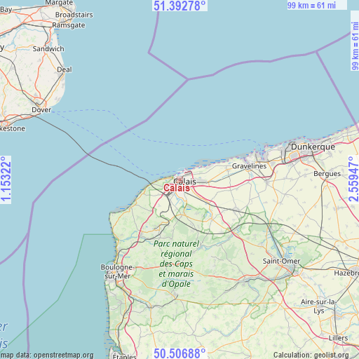
Calais GPS coordinates[2]
50° 57' 6.984" North, 1° 51' 22.86" East
| Map corner | latitude | longitude |
|---|---|---|
| Upper-left | 51.39278°, | 1.15322° |
| Center: | 50.95194°, | 1.85635° |
| Lower-right: | 50.50688°, | 2.55947° |
| Map W x H: | 98.5×98.5 km | = 61.2×61.2mi |
| max Lat: | 51.07786° ⇑0.2% North |
| Calais: | 50.95194° |
| min Lat: | ⇓99.8% South 41.3874° |
| min Long | Calais | max Long |
| -5.08615° | 1.85635° | 9.52242° |
| W 41.3%⇐ | ⇒58.7% E |
Elevation
Elevation of Calais is 6 m = 20 ft, and this is 187.7 m = 616 ft below average elevation for this country.
| Max E: |
2333 m = 7654 ft | 99% |
| Avg. | 193.7 m = 635 ft | |
| Calais | 6 m = 20 ft | |
Min E: |
-1 m = -3 ft | 1% |
See also: Calais elevation on elevation.city.
Geographical zone
Calais is located in North temperate zone (between Tropic of Cancer and the Arctic Circle). Distance of this North polar circle is 1735.8 km =1078.6 mi to North.| Distance of | km | miles | from Calais |
|---|---|---|---|
| North Pole | 4341.7 | 2697.8 | to North |
| Arctic Circle | 1735.8 | 1078.6 | to North |
| Tropic Cancer | 3059.4 | 1901 | to South |
| Equator | 5665.3 | 3520.3 | to South |


Nearby cities:
15 places around Calais: (largest is in red/bold)
• Andres
10.6 km =6.6 mi,  154°
154°
• Bonningues-lès-Calais
8.9 km =5.5 mi,  220°
220°
• Coquelles
4.5 km =2.8 mi,  244°
244°
• Coulogne
3.5 km =2.2 mi, 150°
• Fréthun
4.4 km =2.7 mi,  209°
209°
• Guemps
10.7 km =6.6 mi,  112°
112°
• Guînes
9.5 km =5.9 mi,  174°
174°
• Hames-Boucres
7.9 km =4.9 mi,  186°
186°
• Les Attaques
7 km =4.3 mi,  132°
132°
• Marck
6.1 km =3.8 mi,  93°
93°
• Offekerque
11.5 km =7.1 mi,  95°
95°
• Peuplingues
7.7 km =4.8 mi, 236°
• Saint-Inglevert
11.6 km =7.2 mi, 222°
• Saint-Tricat
6.8 km =4.2 mi,  195°
195°
• Sangatte
7.3 km =4.5 mi,  264°
264°
Sources, notices
• [Note1] Compared only with cities in France existing in our database
• [Src1] Map data: © OpenStreetMap contributors (CC-BY-SA)
• [Src2] Other city data from geonames.org with taken over terms of usage.
• [Src3] Geographical zone / Annual Mean Temperature by Robert A. Rohde @ Wikipedia
