Belleville geodata
Belleville (Grand Est) is a populated place; located in France in Europe/Paris (GMT+2) time zone. With population of 1,306 people, there are 7000 cities with bigger population in this country. Compared to other cities in France, 75.9% of cities are located further ↓South; 88.2% of cities are located further ←West and 63.3% of cities have lower elevation than Belleville. Note1
Administrative division(s):
- Level 1: Grand Est
- Level 2: Meurthe-et-Moselle
- Level 3: Arrondissement de Nancy
- Level 4: Belleville


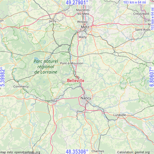
Belleville GPS coordinates[2]
48° 49' 5.412" North, 6° 6' 10.584" East
| Map corner | latitude | longitude |
|---|---|---|
| Upper-left | 49.27901°, | 5.39982° |
| Center: | 48.81817°, | 6.10294° |
| Lower-right: | 48.35306°, | 6.80607° |
| Map W x H: | 103×103 km | = 64×64mi |
| max Lat: | 51.07786° ⇑24.1% North |
| Belleville: | 48.81817° |
| min Lat: | ⇓75.9% South 41.3874° |
| min Long | Belleville | max Long |
| -5.08615° | 6.10294° | 9.52242° |
| W 88.2%⇐ | ⇒11.8% E |
Elevation
Elevation of Belleville is 186 m = 610 ft, and this is 7.7 m = 25 ft below average elevation for this country.
| Max E: |
2333 m = 7654 ft | 36.7% |
| Avg. | 193.7 m = 635 ft | |
| Belleville | 186 m = 610 ft | |
Min E: |
-1 m = -3 ft | 63.3% |
See also: France elevation on elevation.city.
Geographical zone
Belleville is located in North temperate zone (between Tropic of Cancer and the Arctic Circle). Distance of this North polar circle is 1973.1 km =1226 mi to North.| Distance of | km | miles | from Belleville |
|---|---|---|---|
| North Pole | 4579 | 2845.3 | to North |
| Arctic Circle | 1973.1 | 1226 | to North |
| Tropic Cancer | 2822.2 | 1753.6 | to South |
| Equator | 5428.1 | 3372.9 | to South |


Nearby cities:
15 places around Belleville: (largest is in red/bold)
• Atton
8.2 km =5.1 mi,  352°
352°
• Belleau
6.1 km =3.8 mi,  77°
77°
• Blénod-lès-Pont-à-Mousson
8.4 km =5.2 mi,  331°
331°
• Bouxières-aux-Dames
8.3 km =5.2 mi,  148°
148°
• Custines
4.3 km =2.7 mi,  134°
134°
• Dieulouard
3.6 km =2.2 mi,  315°
315°
• Faulx
7.4 km =4.6 mi,  112°
112°
• Frouard
6.8 km =4.2 mi,  162°
162°
• Jezainville
7.5 km =4.7 mi, 323°
• Liverdun
8.1 km =5 mi,  200°
200°
• Maidières
10.2 km =6.3 mi, 333°
• Malleloy
5.1 km =3.2 mi,  120°
120°
• Marbache
2.2 km =1.4 mi,  174°
174°
• Pompey
5.8 km =3.6 mi, 162°
• Saizerais
5.1 km =3.2 mi,  236°
236°
Sources, notices
• [Note1] Compared only with cities in France existing in our database
• [Src1] Map data: © OpenStreetMap contributors (CC-BY-SA)
• [Src2] Other city data from geonames.org with taken over terms of usage.
• [Src3] Geographical zone / Annual Mean Temperature by Robert A. Rohde @ Wikipedia
