Macheren geodata
Macheren (Grand Est) is a populated place; located in France in Europe/Paris (GMT+2) time zone. With population of 2,933 people, there are 3322 cities with bigger population in this country. Compared to other cities in France, 82.2% of cities are located further ↓South; 93.5% of cities are located further ←West and 80.3% of cities have lower elevation than Macheren. Note1
Administrative division(s):
- Level 1: Grand Est
- Level 2: Moselle
- Level 3: Arrondissement de Forbach-Boulay-Moselle
- Level 4: Macheren


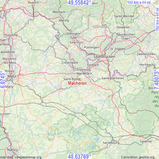
Macheren GPS coordinates[2]
49° 6' 0.684" North, 6° 46' 39.468" East
| Map corner | latitude | longitude |
|---|---|---|
| Upper-left | 49.55842°, | 6.0745° |
| Center: | 49.10019°, | 6.77763° |
| Lower-right: | 48.63769°, | 7.48075° |
| Map W x H: | 102.4×102.4 km | = 63.6×63.6mi |
| max Lat: | 51.07786° ⇑17.8% North |
| Macheren: | 49.10019° |
| min Lat: | ⇓82.2% South 41.3874° |
| min Long | Macheren | max Long |
| -5.08615° | 6.77763° | 9.52242° |
| W 93.5%⇐ | ⇒6.5% E |
Elevation
Elevation of Macheren is 293 m = 961 ft, and this is 99.3 m = 326 ft above average elevation for this country.
| Max E: |
2333 m = 7654 ft | 19.7% |
| Macheren | 293 m 961 ft | |
| Avg. | 193.7 m = 635 ft | |
Min E: |
-1 m = -3 ft | 80.3% |
See also: France elevation on elevation.city.
Geographical zone
Macheren is located in North temperate zone (between Tropic of Cancer and the Arctic Circle). Distance of this North polar circle is 1941.7 km =1206.5 mi to North.| Distance of | km | miles | from Macheren |
|---|---|---|---|
| North Pole | 4547.6 | 2825.7 | to North |
| Arctic Circle | 1941.7 | 1206.5 | to North |
| Tropic Cancer | 2853.5 | 1773.1 | to South |
| Equator | 5459.4 | 3392.3 | to South |


Nearby cities:
15 places around Macheren: (largest is in red/bold)
• Altviller
4.4 km =2.7 mi,  228°
228°
• Barst
5.4 km =3.4 mi,  131°
131°
• Betting
4.1 km =2.5 mi,  43°
43°
• Béning-lès-Saint-Avold
5.9 km =3.7 mi,  49°
49°
• Cappel
6 km =3.7 mi,  121°
121°
• Farébersviller
7 km =4.3 mi,  72°
72°
• Freyming-Merlebach
5.6 km =3.5 mi,  4°
4°
• Guenviller
1.7 km =1.1 mi, 65°
• Henriville
5.7 km =3.5 mi,  92°
92°
• Hombourg-Haut
3.2 km =2 mi,  350°
350°
• Lachambre
3.2 km =2 mi, 228°
• Saint-Avold
5.4 km =3.4 mi,  275°
275°
• Seingbouse
4.2 km =2.6 mi, 69°
• Vahl-Ebersing
5.9 km =3.7 mi,  197°
197°
• Valmont
6.1 km =3.8 mi,  253°
253°
Sources, notices
• [Note1] Compared only with cities in France existing in our database
• [Src1] Map data: © OpenStreetMap contributors (CC-BY-SA)
• [Src2] Other city data from geonames.org with taken over terms of usage.
• [Src3] Geographical zone / Annual Mean Temperature by Robert A. Rohde @ Wikipedia
