Farébersviller geodata
Farébersviller (Grand Est) is a populated place; located in France in Europe/Paris (GMT+2) time zone. With population of 7,068 people, there are 1379 cities with bigger population in this country. Compared to other cities in France, 82.6% of cities are located further ↓South; 94.1% of cities are located further ←West and 80% of cities have lower elevation than Farébersviller. Note1
Administrative division(s):
- Level 1: Grand Est
- Level 2: Moselle
- Level 3: Arrondissement de Forbach-Boulay-Moselle
- Level 4: Farébersviller


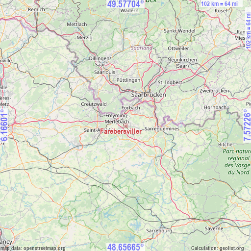
Farébersviller GPS coordinates[2]
49° 7' 8.328" North, 6° 52' 8.904" East
| Map corner | latitude | longitude |
|---|---|---|
| Upper-left | 49.57704°, | 6.16601° |
| Center: | 49.11898°, | 6.86914° |
| Lower-right: | 48.65665°, | 7.57226° |
| Map W x H: | 102.3×102.3 km | = 63.6×63.6mi |
| max Lat: | 51.07786° ⇑17.4% North |
| Farébersviller: | 49.11898° |
| min Lat: | ⇓82.6% South 41.3874° |
| min Long | Farébersviller | max Long |
| -5.08615° | 6.86914° | 9.52242° |
| W 94.1%⇐ | ⇒5.9% E |
Elevation
Elevation of Farébersviller is 290 m = 951 ft, and this is 96.3 m = 316 ft above average elevation for this country.
| Max E: |
2333 m = 7654 ft | 20% |
| Farébersviller | 290 m 951 ft | |
| Avg. | 193.7 m = 635 ft | |
Min E: |
-1 m = -3 ft | 80% |
See also: France elevation on elevation.city.
Geographical zone
Farébersviller is located in North temperate zone (between Tropic of Cancer and the Arctic Circle). Distance of this North polar circle is 1939.7 km =1205.3 mi to North.| Distance of | km | miles | from Farébersviller |
|---|---|---|---|
| North Pole | 4545.5 | 2824.4 | to North |
| Arctic Circle | 1939.7 | 1205.3 | to North |
| Tropic Cancer | 2855.6 | 1774.4 | to South |
| Equator | 5461.5 | 3393.6 | to South |


Nearby cities:
15 places around Farébersviller: (largest is in red/bold)
• Betting
3.9 km =2.4 mi,  282°
282°
• Béning-lès-Saint-Avold
2.8 km =1.7 mi,  309°
309°
• Cappel
5.4 km =3.4 mi,  196°
196°
• Cocheren
2.9 km =1.8 mi,  341°
341°
• Diebling
5.2 km =3.2 mi,  101°
101°
• Farschviller
3.4 km =2.1 mi,  145°
145°
• Folkling
3.7 km =2.3 mi,  30°
30°
• Guenviller
5.3 km =3.3 mi,  254°
254°
• Henriville
2.5 km =1.6 mi, 203°
• Loupershouse
5.4 km =3.4 mi,  142°
142°
• Morsbach
5.5 km =3.4 mi,  2°
2°
• Rosbruck
4.6 km =2.9 mi, 342°
• Seingbouse
2.8 km =1.7 mi,  257°
257°
• Tenteling
5 km =3.1 mi,  81°
81°
• Théding
2 km =1.2 mi,  57°
57°
Sources, notices
• [Note1] Compared only with cities in France existing in our database
• [Src1] Map data: © OpenStreetMap contributors (CC-BY-SA)
• [Src2] Other city data from geonames.org with taken over terms of usage.
• [Src3] Geographical zone / Annual Mean Temperature by Robert A. Rohde @ Wikipedia
