Cappel geodata
Cappel (Grand Est) is a populated place; located in France in Europe/Paris (GMT+2) time zone. With population of 746 people, there are 11210 cities with bigger population in this country. Compared to other cities in France, 81.4% of cities are located further ↓South; 93.9% of cities are located further ←West and 75.6% of cities have lower elevation than Cappel. Note1
Administrative division(s):
- Level 1: Grand Est
- Level 2: Moselle
- Level 3: Arrondissement de Forbach-Boulay-Moselle
- Level 4: Cappel


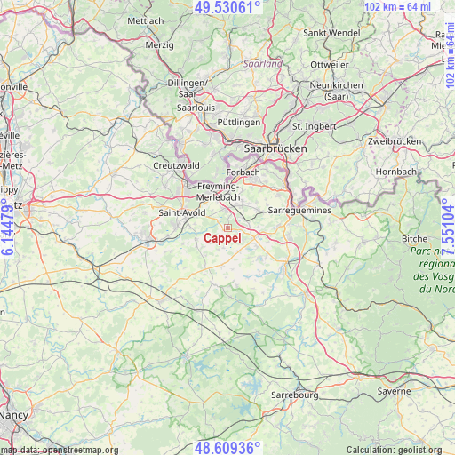
Cappel GPS coordinates[2]
49° 4' 19.632" North, 6° 50' 52.512" East
| Map corner | latitude | longitude |
|---|---|---|
| Upper-left | 49.53061°, | 6.14479° |
| Center: | 49.07212°, | 6.84792° |
| Lower-right: | 48.60936°, | 7.55104° |
| Map W x H: | 102.4×102.4 km | = 63.6×63.6mi |
| max Lat: | 51.07786° ⇑18.6% North |
| Cappel: | 49.07212° |
| min Lat: | ⇓81.4% South 41.3874° |
| min Long | Cappel | max Long |
| -5.08615° | 6.84792° | 9.52242° |
| W 93.9%⇐ | ⇒6.1% E |
Elevation
Elevation of Cappel is 254 m = 833 ft, and this is 60.3 m = 198 ft above average elevation for this country.
| Max E: |
2333 m = 7654 ft | 24.4% |
| Cappel | 254 m 833 ft | |
| Avg. | 193.7 m = 635 ft | |
Min E: |
-1 m = -3 ft | 75.6% |
See also: France elevation on elevation.city.
Geographical zone
Cappel is located in North temperate zone (between Tropic of Cancer and the Arctic Circle). Distance of this North polar circle is 1944.9 km =1208.5 mi to North.| Distance of | km | miles | from Cappel |
|---|---|---|---|
| North Pole | 4550.8 | 2827.7 | to North |
| Arctic Circle | 1944.9 | 1208.5 | to North |
| Tropic Cancer | 2850.4 | 1771.2 | to South |
| Equator | 5456.3 | 3390.4 | to South |


Nearby cities:
15 places around Cappel: (largest is in red/bold)
• Barst
1.1 km =0.7 mi,  248°
248°
• Betting
6.5 km =4 mi,  339°
339°
• Béning-lès-Saint-Avold
7 km =4.3 mi,  354°
354°
• Farschviller
4.2 km =2.6 mi,  54°
54°
• Farébersviller
5.4 km =3.4 mi,  16°
16°
• Guenviller
5.2 km =3.2 mi,  316°
316°
• Henriville
2.9 km =1.8 mi,  10°
10°
• Lachambre
7.5 km =4.7 mi,  277°
277°
• Laning
6.8 km =4.2 mi,  232°
232°
• Loupershouse
4.9 km =3 mi,  79°
79°
• Macheren
6 km =3.7 mi,  301°
301°
• Saint-Jean-Rohrbach
5.8 km =3.6 mi,  152°
152°
• Seingbouse
4.7 km =2.9 mi, 345°
• Théding
7 km =4.3 mi,  27°
27°
• Vahl-Ebersing
7.4 km =4.6 mi, 250°
Sources, notices
• [Note1] Compared only with cities in France existing in our database
• [Src1] Map data: © OpenStreetMap contributors (CC-BY-SA)
• [Src2] Other city data from geonames.org with taken over terms of usage.
• [Src3] Geographical zone / Annual Mean Temperature by Robert A. Rohde @ Wikipedia
