Saint-Gingolph geodata
Saint-Gingolph (Auvergne-Rhône-Alpes) is a populated place; located in France in Europe/Paris (GMT+2) time zone. With population of 640 people, there are 12673 cities with bigger population in this country. Compared to other cities in France, 61.2% of cities are located further ↑North; 93.6% of cities are located further ←West and 88% of cities have lower elevation than Saint-Gingolph. Note1
Administrative division(s):
- Level 1: Auvergne-Rhône-Alpes
- Level 2: Haute-Savoie
- Level 3: Arrondissement de Thonon-les-Bains
- Level 4: Saint-Gingolph


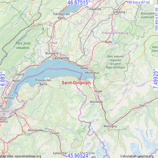
Saint-Gingolph GPS coordinates[2]
46° 23' 32.46" North, 6° 47' 46.032" East
| Map corner | latitude | longitude |
|---|---|---|
| Upper-left | 46.87515°, | 6.093° |
| Center: | 46.39235°, | 6.79612° |
| Lower-right: | 45.90524°, | 7.49925° |
| Map W x H: | 107.8×107.8 km | = 67×67mi |
| max Lat: | 51.07786° ⇑61.2% North |
| Saint-Gingolph: | 46.39235° |
| min Lat: | ⇓38.8% South 41.3874° |
| min Long | Saint-Gingolph | max Long |
| -5.08615° | 6.79612° | 9.52242° |
| W 93.6%⇐ | ⇒6.4% E |
Elevation
Elevation of Saint-Gingolph is 389 m = 1276 ft, and this is 195.3 m = 641 ft above average elevation for this country.
| Max E: |
2333 m = 7654 ft | 12% |
| Saint-Gingolph | 389 m 1276 ft | |
| Avg. | 193.7 m = 635 ft | |
Min E: |
-1 m = -3 ft | 88% |
See also: France elevation on elevation.city.
Geographical zone
Saint-Gingolph is located in North temperate zone (between Tropic of Cancer and the Arctic Circle). Distance of this North polar circle is 2242.8 km =1393.6 mi to North.| Distance of | km | miles | from Saint-Gingolph |
|---|---|---|---|
| North Pole | 4848.7 | 3012.8 | to North |
| Arctic Circle | 2242.8 | 1393.6 | to North |
| Tropic Cancer | 2552.4 | 1586 | to South |
| Equator | 5158.3 | 3205.2 | to South |


Nearby cities:
15 places around Saint-Gingolph: (largest is in red/bold)
• Abondance
13.9 km =8.6 mi,  204°
204°
• Bernex
9.7 km =6 mi,  249°
249°
• Champanges
18.8 km =11.7 mi,  263°
263°
• Chevenoz
13.6 km =8.5 mi,  244°
244°
• Châtel
14.6 km =9.1 mi,  166°
166°
• Féternes
19.4 km =12.1 mi, 257°
• Larringes
17.4 km =10.8 mi, 261°
• Lugrin
11 km =6.8 mi,  275°
275°
• Maxilly-sur-Léman
12.7 km =7.9 mi,  272°
272°
• Neuvecelle
14.1 km =8.8 mi, 271°
• Saint-Paul-en-Chablais
13.2 km =8.2 mi, 263°
• Thollon-les-Mémises
6.2 km =3.9 mi, 260°
• Vacheresse
12 km =7.5 mi,  231°
231°
• Vinzier
14.4 km =8.9 mi, 250°
• Évian-les-Bains
16 km =9.9 mi, 273°
Sources, notices
• [Note1] Compared only with cities in France existing in our database
• [Src1] Map data: © OpenStreetMap contributors (CC-BY-SA)
• [Src2] Other city data from geonames.org with taken over terms of usage.
• [Src3] Geographical zone / Annual Mean Temperature by Robert A. Rohde @ Wikipedia
