Longchamp geodata
Longchamp (Bourgogne-Franche-Comté) is a populated place; located in France in Europe/Paris (GMT+2) time zone. With population of 1,171 people, there are 7703 cities with bigger population in this country. Compared to other cities in France, 52.2% of cities are located further ↑North; 80.5% of cities are located further ←West and 66.8% of cities have lower elevation than Longchamp. Note1
Administrative division(s):
- Level 1: Bourgogne-Franche-Comté
- Level 2: Département de la Côte-d'Or
- Level 3: Arrondissement de Dijon
- Level 4: Longchamp


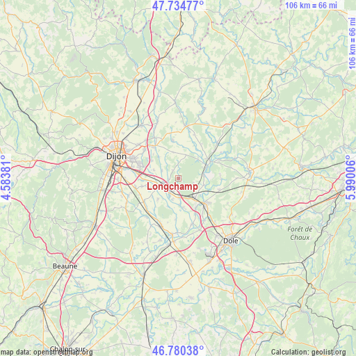
Longchamp GPS coordinates[2]
47° 15' 35.028" North, 5° 17' 12.984" East
| Map corner | latitude | longitude |
|---|---|---|
| Upper-left | 47.73477°, | 4.58381° |
| Center: | 47.25973°, | 5.28694° |
| Lower-right: | 46.78038°, | 5.99006° |
| Map W x H: | 106.1×106.1 km | = 65.9×65.9mi |
| max Lat: | 51.07786° ⇑52.2% North |
| Longchamp: | 47.25973° |
| min Lat: | ⇓47.8% South 41.3874° |
| min Long | Longchamp | max Long |
| -5.08615° | 5.28694° | 9.52242° |
| W 80.5%⇐ | ⇒19.5% E |
Elevation
Elevation of Longchamp is 203 m = 666 ft, and this is 9.3 m = 31 ft above average elevation for this country.
| Max E: |
2333 m = 7654 ft | 33.2% |
| Longchamp | 203 m 666 ft | |
| Avg. | 193.7 m = 635 ft | |
Min E: |
-1 m = -3 ft | 66.8% |
See also: France elevation on elevation.city.
Geographical zone
Longchamp is located in North temperate zone (between Tropic of Cancer and the Arctic Circle). Distance of this North polar circle is 2146.4 km =1333.7 mi to North.| Distance of | km | miles | from Longchamp |
|---|---|---|---|
| North Pole | 4752.3 | 2952.9 | to North |
| Arctic Circle | 2146.4 | 1333.7 | to North |
| Tropic Cancer | 2648.9 | 1645.9 | to South |
| Equator | 5254.8 | 3265.2 | to South |


Nearby cities:
15 places around Longchamp: (largest is in red/bold)
• Athée
7.3 km =4.5 mi,  117°
117°
• Binges
7.9 km =4.9 mi,  349°
349°
• Bressey-sur-Tille
9.5 km =5.9 mi,  304°
304°
• Champdôtre
8.8 km =5.5 mi,  171°
171°
• Collonges-lès-Premières
4.2 km =2.6 mi,  201°
201°
• Genlis
5.1 km =3.2 mi,  247°
247°
• Izier
7.8 km =4.8 mi,  288°
288°
• Lamarche-sur-Saône
7.5 km =4.7 mi,  81°
81°
• Longeault
5 km =3.1 mi,  210°
210°
• Magny-sur-Tille
8.9 km =5.5 mi,  281°
281°
• Pluvault
5.8 km =3.6 mi, 205°
• Remilly-sur-Tille
8.7 km =5.4 mi,  316°
316°
• Tart-le-Haut
8.8 km =5.5 mi,  224°
224°
• Varanges
7.6 km =4.7 mi, 245°
• Villers-les-Pots
6.8 km =4.2 mi,  135°
135°
Sources, notices
• [Note1] Compared only with cities in France existing in our database
• [Src1] Map data: © OpenStreetMap contributors (CC-BY-SA)
• [Src2] Other city data from geonames.org with taken over terms of usage.
• [Src3] Geographical zone / Annual Mean Temperature by Robert A. Rohde @ Wikipedia
