Pluvault geodata
Pluvault (Bourgogne-Franche-Comté) is a populated place; located in France in Europe/Paris (GMT+2) time zone. With population of 525 people, there are 14719 cities with bigger population in this country. Compared to other cities in France, 52.9% of cities are located further ↑North; 80.2% of cities are located further ←West and 65% of cities have lower elevation than Pluvault. Note1
Administrative division(s):
- Level 1: Bourgogne-Franche-Comté
- Level 2: Département de la Côte-d'Or
- Level 3: Arrondissement de Dijon
- Level 4: Longeault-Pluvault


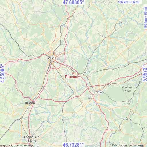
Pluvault GPS coordinates[2]
47° 12' 45.288" North, 5° 15' 14.688" East
| Map corner | latitude | longitude |
|---|---|---|
| Upper-left | 47.68805°, | 4.55095° |
| Center: | 47.21258°, | 5.25408° |
| Lower-right: | 46.73281°, | 5.9572° |
| Map W x H: | 106.2×106.2 km | = 66×66mi |
| max Lat: | 51.07786° ⇑52.9% North |
| Pluvault: | 47.21258° |
| min Lat: | ⇓47.1% South 41.3874° |
| min Long | Pluvault | max Long |
| -5.08615° | 5.25408° | 9.52242° |
| W 80.2%⇐ | ⇒19.8% E |
Elevation
Elevation of Pluvault is 194 m = 636 ft, and this is 0.30000000000001 m = 1 ft above average elevation for this country.
| Max E: |
2333 m = 7654 ft | 35% |
| Pluvault | 194 m 636 ft | |
| Avg. | 193.7 m = 635 ft | |
Min E: |
-1 m = -3 ft | 65% |
See also: France elevation on elevation.city.
Geographical zone
Pluvault is located in North temperate zone (between Tropic of Cancer and the Arctic Circle). Distance of this North polar circle is 2151.6 km =1336.9 mi to North.| Distance of | km | miles | from Pluvault |
|---|---|---|---|
| North Pole | 4757.5 | 2956.2 | to North |
| Arctic Circle | 2151.6 | 1336.9 | to North |
| Tropic Cancer | 2643.6 | 1642.7 | to South |
| Equator | 5249.5 | 3261.9 | to South |


Nearby cities:
15 places around Pluvault: (largest is in red/bold)
• Aiserey
8.2 km =5.1 mi,  237°
237°
• Brazey-en-Plaine
8.8 km =5.5 mi,  199°
199°
• Champdôtre
5.1 km =3.2 mi,  132°
132°
• Collonges-lès-Premières
1.6 km =1 mi,  35°
35°
• Genlis
4 km =2.5 mi,  325°
325°
• Longchamp
5.8 km =3.6 mi,  25°
25°
• Longeault
0.9 km =0.6 mi,  357°
357°
• Longecourt-en-Plaine
8.1 km =5 mi,  258°
258°
• Rouvres-en-Plaine
9 km =5.6 mi,  289°
289°
• Tart-le-Haut
3.8 km =2.4 mi, 255°
• Thorey-en-Plaine
9.1 km =5.7 mi,  272°
272°
• Tillenay
8.2 km =5.1 mi,  117°
117°
• Trouhans
7.3 km =4.5 mi,  167°
167°
• Varanges
4.9 km =3 mi, 294°
• Villers-les-Pots
7.3 km =4.5 mi,  86°
86°
Sources, notices
• [Note1] Compared only with cities in France existing in our database
• [Src1] Map data: © OpenStreetMap contributors (CC-BY-SA)
• [Src2] Other city data from geonames.org with taken over terms of usage.
• [Src3] Geographical zone / Annual Mean Temperature by Robert A. Rohde @ Wikipedia
