Loiron geodata
Loiron (Pays de la Loire) is a populated place; located in France in Europe/Paris (GMT+2) time zone. With population of 1,342 people, there are 6859 cities with bigger population in this country. Compared to other cities in France, 60.5% of cities are located further ↓South; 87.6% of cities are located further →East and 53.6% of cities have lower elevation than Loiron. Note1
Administrative division(s):
- Level 1: Pays de la Loire
- Level 2: Mayenne
- Level 3: Arrondissement de Laval
- Level 4: Loiron-Ruillé


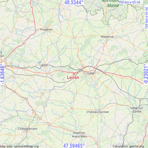
Loiron GPS coordinates[2]
48° 4' 0.012" North, 0° 55' 59.988" West
| Map corner | latitude | longitude |
|---|---|---|
| Upper-left | 48.5344°, | -1.63646° |
| Center: | 48.06667°, | -0.93333° |
| Lower-right: | 47.59465°, | -0.23021° |
| Map W x H: | 104.5×104.5 km | = 64.9×64.9mi |
| max Lat: | 51.07786° ⇑39.5% North |
| Loiron: | 48.06667° |
| min Lat: | ⇓60.5% South 41.3874° |
| min Long | Loiron | max Long |
| -5.08615° | -0.93333° | 9.52242° |
| W 12.4%⇐ | ⇒87.6% E |
Elevation
Elevation of Loiron is 145 m = 476 ft, and this is 48.7 m = 160 ft below average elevation for this country.
| Max E: |
2333 m = 7654 ft | 46.4% |
| Avg. | 193.7 m = 635 ft | |
| Loiron | 145 m = 476 ft | |
Min E: |
-1 m = -3 ft | 53.6% |
See also: France elevation on elevation.city.
Geographical zone
Loiron is located in North temperate zone (between Tropic of Cancer and the Arctic Circle). Distance of this North polar circle is 2056.7 km =1278 mi to North.| Distance of | km | miles | from Loiron |
|---|---|---|---|
| North Pole | 4662.5 | 2897.1 | to North |
| Arctic Circle | 2056.7 | 1278 | to North |
| Tropic Cancer | 2738.6 | 1701.7 | to South |
| Equator | 5344.5 | 3320.9 | to South |


Nearby cities:
15 places around Loiron: (largest is in red/bold)
• Ahuillé
7 km =4.3 mi,  136°
136°
• Bréal-sous-Vitré
10.3 km =6.4 mi,  293°
293°
• Changé
11 km =6.8 mi,  70°
70°
• Courbeveille
9 km =5.6 mi,  157°
157°
• La Brûlatte
2.6 km =1.6 mi,  323°
323°
• La Gravelle
6.2 km =3.9 mi,  276°
276°
• Le Pertre
8.6 km =5.3 mi,  244°
244°
• Montigné-le-Brillant
10.9 km =6.8 mi,  126°
126°
• Montjean
7.2 km =4.5 mi,  197°
197°
• Port-Brillet
5.9 km =3.7 mi,  331°
331°
• Ruillé-le-Gravelais
1.9 km =1.2 mi,  234°
234°
• Saint-Berthevin
7.4 km =4.6 mi,  90°
90°
• Saint-Cyr-le-Gravelais
7.8 km =4.8 mi, 242°
• Saint-Ouën-des-Toits
7.8 km =4.8 mi,  18°
18°
• Saint-Pierre-la-Cour
8.5 km =5.3 mi,  306°
306°
Sources, notices
• [Note1] Compared only with cities in France existing in our database
• [Src1] Map data: © OpenStreetMap contributors (CC-BY-SA)
• [Src2] Other city data from geonames.org with taken over terms of usage.
• [Src3] Geographical zone / Annual Mean Temperature by Robert A. Rohde @ Wikipedia
