Saint-Pierre-la-Cour geodata
Saint-Pierre-la-Cour (Pays de la Loire) is a populated place; located in France in Europe/Paris (GMT+2) time zone. With population of 1,711 people, there are 5491 cities with bigger population in this country. Compared to other cities in France, 61.4% of cities are located further ↓South; 88.4% of cities are located further →East and 50.1% of cities have lower elevation than Saint-Pierre-la-Cour. Note1
Administrative division(s):
- Level 1: Pays de la Loire
- Level 2: Mayenne
- Level 3: Arrondissement de Laval
- Level 4: Saint-Pierre-la-Cour


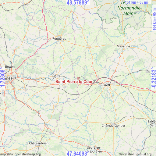
Saint-Pierre-la-Cour GPS coordinates[2]
48° 6' 45.288" North, 1° 1' 29.856" West
| Map corner | latitude | longitude |
|---|---|---|
| Upper-left | 48.57989°, | -1.72808° |
| Center: | 48.11258°, | -1.02496° |
| Lower-right: | 47.64098°, | -0.32183° |
| Map W x H: | 104.4×104.4 km | = 64.9×64.9mi |
| max Lat: | 51.07786° ⇑38.6% North |
| Saint-Pierre-la-Cour: | 48.11258° |
| min Lat: | ⇓61.4% South 41.3874° |
| min Long | Saint-Pierre-la | max Long |
| -5.08615° | -1.02496° | 9.52242° |
| W 11.6%⇐ | ⇒88.4% E |
Elevation
Elevation of Saint-Pierre-la-Cour is 132 m = 433 ft, and this is 61.7 m = 202 ft below average elevation for this country.
| Max E: |
2333 m = 7654 ft | 49.9% |
| Avg. | 193.7 m = 635 ft | |
| Saint-Pierre-la-Cour | 132 m = 433 ft | |
Min E: |
-1 m = -3 ft | 50.1% |
See also: France elevation on elevation.city.
Geographical zone
Saint-Pierre-la-Cour is located in North temperate zone (between Tropic of Cancer and the Arctic Circle). Distance of this North polar circle is 2051.6 km =1274.8 mi to North.| Distance of | km | miles | from Saint-Pierre-la-Cour |
|---|---|---|---|
| North Pole | 4657.4 | 2894 | to North |
| Arctic Circle | 2051.6 | 1274.8 | to North |
| Tropic Cancer | 2743.7 | 1704.9 | to South |
| Equator | 5349.6 | 3324.1 | to South |


Nearby cities:
15 places around Saint-Pierre-la-Cour: (largest is in red/bold)
• Argentré-du-Plessis
10.9 km =6.8 mi,  235°
235°
• Bourgon
6.8 km =4.2 mi,  332°
332°
• Bréal-sous-Vitré
2.9 km =1.8 mi,  248°
248°
• Erbrée
7.6 km =4.7 mi,  257°
257°
• La Brûlatte
6 km =3.7 mi,  119°
119°
• La Croixille
10.5 km =6.5 mi,  346°
346°
• La Gravelle
4.5 km =2.8 mi,  171°
171°
• Le Bourgneuf-la-Forêt
7 km =4.3 mi,  36°
36°
• Le Pertre
8.8 km =5.5 mi,  185°
185°
• Loiron
8.5 km =5.3 mi,  126°
126°
• Mondevert
6.5 km =4 mi, 239°
• Port-Brillet
4 km =2.5 mi,  89°
89°
• Ruillé-le-Gravelais
8.1 km =5 mi,  139°
139°
• Saint-Cyr-le-Gravelais
8.7 km =5.4 mi,  181°
181°
• Saint-Ouën-des-Toits
9.6 km =6 mi,  76°
76°
Sources, notices
• [Note1] Compared only with cities in France existing in our database
• [Src1] Map data: © OpenStreetMap contributors (CC-BY-SA)
• [Src2] Other city data from geonames.org with taken over terms of usage.
• [Src3] Geographical zone / Annual Mean Temperature by Robert A. Rohde @ Wikipedia
