Lille geodata
Lille (Hauts-de-France) is a seat of a first-order administrative division; located in France in Europe/Paris (GMT+2) time zone. With population of 228,328 people, there are 9 cities with bigger population in this country. Compared to other cities in France, 98.3% of cities are located further ↓South; 58.6% of cities are located further ←West and 91.2% of cities have higher elevation than Lille. Note1
Administrative division(s):
- Level 1: Hauts-de-France
- Level 2: Nord
- Level 3: Arrondissement de Lille
- Level 4: Lille


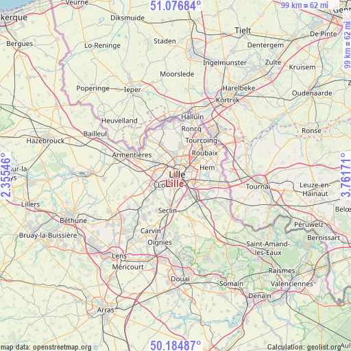
Lille GPS coordinates[2]
50° 37' 58.692" North, 3° 3' 30.888" East
| Map corner | latitude | longitude |
|---|---|---|
| Upper-left | 51.07684°, | 2.35546° |
| Center: | 50.63297°, | 3.05858° |
| Lower-right: | 50.18487°, | 3.76171° |
| Map W x H: | 99.2×99.2 km | = 61.6×61.6mi |
| max Lat: | 51.07786° ⇑1.7% North |
| Lille: | 50.63297° |
| min Lat: | ⇓98.3% South 41.3874° |
| min Long | Lille | max Long |
| -5.08615° | 3.05858° | 9.52242° |
| W 58.6%⇐ | ⇒41.4% E |
Elevation
Elevation of Lille is 27 m = 89 ft, and this is 166.7 m = 547 ft below average elevation for this country.
| Max E: |
2333 m = 7654 ft | 91.2% |
| Avg. | 193.7 m = 635 ft | |
| Lille | 27 m = 89 ft | |
Min E: |
-1 m = -3 ft | 8.8% |
See also: Lille elevation on elevation.city.
Geographical zone
Lille is located in North temperate zone (between Tropic of Cancer and the Arctic Circle). Distance of this North polar circle is 1771.3 km =1100.6 mi to North.| Distance of | km | miles | from Lille |
|---|---|---|---|
| North Pole | 4377.2 | 2719.9 | to North |
| Arctic Circle | 1771.3 | 1100.6 | to North |
| Tropic Cancer | 3023.9 | 1879 | to South |
| Equator | 5629.9 | 3498.3 | to South |


Nearby cities:
15 places around Lille: (largest is in red/bold)
• Faches-Thumesnil
5.5 km =3.4 mi,  174°
174°
• Haubourdin
5.5 km =3.4 mi,  239°
239°
• La Madeleine
1.9 km =1.2 mi,  39°
39°
• Lambersart
2.6 km =1.6 mi,  316°
316°
• Lezennes
4.3 km =2.7 mi,  116°
116°
• Lomme
5.2 km =3.2 mi,  283°
283°
• Loos
3.8 km =2.4 mi,  227°
227°
• Marcq-en-Barœul
4.1 km =2.5 mi,  24°
24°
• Marquette-lez-Lille
4.8 km =3 mi,  6°
6°
• Mons-en-Barœul
4.1 km =2.5 mi,  89°
89°
• Ronchin
4.4 km =2.7 mi,  149°
149°
• Saint-André-lez-Lille
3.8 km =2.4 mi,  350°
350°
• Sequedin
5.4 km =3.4 mi,  261°
261°
• Wambrechies
5.6 km =3.5 mi, 352°
• Wattignies
5.3 km =3.3 mi,  191°
191°
Sources, notices
• [Note1] Compared only with cities in France existing in our database
• [Src1] Map data: © OpenStreetMap contributors (CC-BY-SA)
• [Src2] Other city data from geonames.org with taken over terms of usage.
• [Src3] Geographical zone / Annual Mean Temperature by Robert A. Rohde @ Wikipedia
