Lambersart geodata
Lambersart (Hauts-de-France) is a populated place; located in France in Europe/Paris (GMT+2) time zone. With population of 28,613 people, there are 296 cities with bigger population in this country. Compared to other cities in France, 98.5% of cities are located further ↓South; 58.3% of cities are located further ←West and 92.4% of cities have higher elevation than Lambersart. Note1
Administrative division(s):
- Level 1: Hauts-de-France
- Level 2: Nord
- Level 3: Arrondissement de Lille
- Level 4: Lambersart


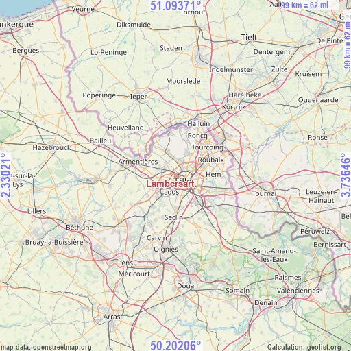
Lambersart GPS coordinates[2]
50° 39' 0" North, 3° 1' 59.988" East
| Map corner | latitude | longitude |
|---|---|---|
| Upper-left | 51.09371°, | 2.33021° |
| Center: | 50.65°, | 3.03333° |
| Lower-right: | 50.20206°, | 3.73646° |
| Map W x H: | 99.1×99.1 km | = 61.6×61.6mi |
| max Lat: | 51.07786° ⇑1.5% North |
| Lambersart: | 50.65° |
| min Lat: | ⇓98.5% South 41.3874° |
| min Long | Lambersart | max Long |
| -5.08615° | 3.03333° | 9.52242° |
| W 58.3%⇐ | ⇒41.7% E |
Elevation
Elevation of Lambersart is 24 m = 79 ft, and this is 169.7 m = 557 ft below average elevation for this country.
| Max E: |
2333 m = 7654 ft | 92.4% |
| Avg. | 193.7 m = 635 ft | |
| Lambersart | 24 m = 79 ft | |
Min E: |
-1 m = -3 ft | 7.6% |
See also: France elevation on elevation.city.
Geographical zone
Lambersart is located in North temperate zone (between Tropic of Cancer and the Arctic Circle). Distance of this North polar circle is 1769.4 km =1099.5 mi to North.| Distance of | km | miles | from Lambersart |
|---|---|---|---|
| North Pole | 4375.3 | 2718.7 | to North |
| Arctic Circle | 1769.4 | 1099.5 | to North |
| Tropic Cancer | 3025.8 | 1880.1 | to South |
| Equator | 5631.8 | 3499.4 | to South |


Nearby cities:
15 places around Lambersart: (largest is in red/bold)
• Capinghem
5.1 km =3.2 mi,  264°
264°
• Haubourdin
5.5 km =3.4 mi,  212°
212°
• La Madeleine
3 km =1.9 mi,  98°
98°
• Lille
2.6 km =1.6 mi,  136°
136°
• Lomme
3.3 km =2.1 mi, 257°
• Lompret
3.8 km =2.4 mi,  304°
304°
• Loos
4.6 km =2.9 mi,  192°
192°
• Marcq-en-Barœul
4 km =2.5 mi,  62°
62°
• Marquette-lez-Lille
3.7 km =2.3 mi,  38°
38°
• Prémesques
5.8 km =3.6 mi,  276°
276°
• Pérenchies
5 km =3.1 mi, 296°
• Saint-André-lez-Lille
2.2 km =1.4 mi,  32°
32°
• Sequedin
4.5 km =2.8 mi,  232°
232°
• Verlinghem
4.4 km =2.7 mi,  326°
326°
• Wambrechies
3.8 km =2.4 mi,  15°
15°
Sources, notices
• [Note1] Compared only with cities in France existing in our database
• [Src1] Map data: © OpenStreetMap contributors (CC-BY-SA)
• [Src2] Other city data from geonames.org with taken over terms of usage.
• [Src3] Geographical zone / Annual Mean Temperature by Robert A. Rohde @ Wikipedia
