Ronchin geodata
Ronchin (Hauts-de-France) is a populated place; located in France in Europe/Paris (GMT+2) time zone. With population of 18,331 people, there are 514 cities with bigger population in this country. Compared to other cities in France, 98.1% of cities are located further ↓South; 59.2% of cities are located further ←West and 84.9% of cities have higher elevation than Ronchin. Note1
Administrative division(s):
- Level 1: Hauts-de-France
- Level 2: Nord
- Level 3: Arrondissement de Lille
- Level 4: Ronchin


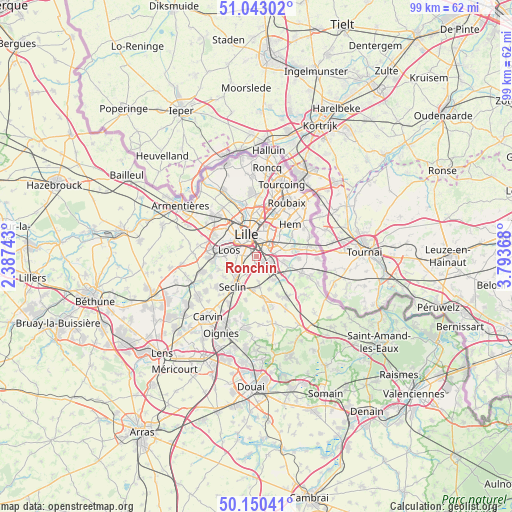
Ronchin GPS coordinates[2]
50° 35' 55.788" North, 3° 5' 26.016" East
| Map corner | latitude | longitude |
|---|---|---|
| Upper-left | 51.04302°, | 2.38743° |
| Center: | 50.59883°, | 3.09056° |
| Lower-right: | 50.15041°, | 3.79368° |
| Map W x H: | 99.2×99.2 km | = 61.6×61.6mi |
| max Lat: | 51.07786° ⇑1.9% North |
| Ronchin: | 50.59883° |
| min Lat: | ⇓98.1% South 41.3874° |
| min Long | Ronchin | max Long |
| -5.08615° | 3.09056° | 9.52242° |
| W 59.2%⇐ | ⇒40.8% E |
Elevation
Elevation of Ronchin is 42 m = 138 ft, and this is 151.7 m = 498 ft below average elevation for this country.
| Max E: |
2333 m = 7654 ft | 84.9% |
| Avg. | 193.7 m = 635 ft | |
| Ronchin | 42 m = 138 ft | |
Min E: |
-1 m = -3 ft | 15.1% |
See also: France elevation on elevation.city.
Geographical zone
Ronchin is located in North temperate zone (between Tropic of Cancer and the Arctic Circle). Distance of this North polar circle is 1775.1 km =1103 mi to North.| Distance of | km | miles | from Ronchin |
|---|---|---|---|
| North Pole | 4381 | 2722.2 | to North |
| Arctic Circle | 1775.1 | 1103 | to North |
| Tropic Cancer | 3020.1 | 1876.6 | to South |
| Equator | 5626.1 | 3495.9 | to South |


Nearby cities:
15 places around Ronchin: (largest is in red/bold)
• Emmerin
6.3 km =3.9 mi,  265°
265°
• Faches-Thumesnil
2.4 km =1.5 mi,  224°
224°
• Fretin
5.6 km =3.5 mi,  144°
144°
• La Madeleine
5.3 km =3.3 mi,  348°
348°
• Lesquin
2.7 km =1.7 mi,  132°
132°
• Lezennes
2.5 km =1.6 mi,  41°
41°
• Lille
4.4 km =2.7 mi,  329°
329°
• Loos
5.2 km =3.2 mi,  283°
283°
• Mons-en-Barœul
4.3 km =2.7 mi,  25°
25°
• Noyelles-lès-Seclin
5.8 km =3.6 mi,  244°
244°
• Sainghin-en-Mélantois
5.5 km =3.4 mi,  102°
102°
• Templemars
3.8 km =2.4 mi, 222°
• Vendeville
2.6 km =1.6 mi,  198°
198°
• Villeneuve-d'Ascq
5.7 km =3.5 mi,  69°
69°
• Wattignies
3.6 km =2.2 mi,  247°
247°
Sources, notices
• [Note1] Compared only with cities in France existing in our database
• [Src1] Map data: © OpenStreetMap contributors (CC-BY-SA)
• [Src2] Other city data from geonames.org with taken over terms of usage.
• [Src3] Geographical zone / Annual Mean Temperature by Robert A. Rohde @ Wikipedia
