Le Theil-Bocage geodata
Le Theil-Bocage (Normandy) is a populated place; located in France in Europe/Paris (GMT+2) time zone. With population of 1,955 people, there are 4896 cities with bigger population in this country. Compared to other cities in France, 77.2% of cities are located further ↓South; 85.7% of cities are located further →East and 69.8% of cities have lower elevation than Le Theil-Bocage. Note1
Administrative division(s):
- Level 1: Normandy
- Level 2: Calvados
- Level 3: Arrondissement de Vire
- Level 4: Valdallière


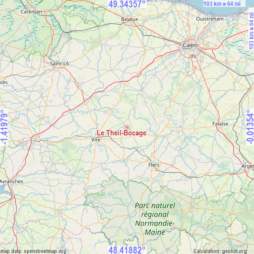
Le Theil-Bocage GPS coordinates[2]
48° 52' 59.988" North, 0° 43' 0.012" West
| Map corner | latitude | longitude |
|---|---|---|
| Upper-left | 49.34357°, | -1.41979° |
| Center: | 48.88333°, | -0.71667° |
| Lower-right: | 48.41882°, | -0.01354° |
| Map W x H: | 102.8×102.8 km | = 63.9×63.9mi |
| max Lat: | 51.07786° ⇑22.8% North |
| Le Theil-Bocage: | 48.88333° |
| min Lat: | ⇓77.2% South 41.3874° |
| min Long | Le Theil-Bocage | max Long |
| -5.08615° | -0.71667° | 9.52242° |
| W 14.3%⇐ | ⇒85.7% E |
Elevation
Elevation of Le Theil-Bocage is 218 m = 715 ft, and this is 24.3 m = 80 ft above average elevation for this country.
| Max E: |
2333 m = 7654 ft | 30.2% |
| Le Theil-Bocage | 218 m 715 ft | |
| Avg. | 193.7 m = 635 ft | |
Min E: |
-1 m = -3 ft | 69.8% |
See also: France elevation on elevation.city.
Geographical zone
Le Theil-Bocage is located in North temperate zone (between Tropic of Cancer and the Arctic Circle). Distance of this North polar circle is 1965.9 km =1221.6 mi to North.| Distance of | km | miles | from Le Theil-Bocage |
|---|---|---|---|
| North Pole | 4571.7 | 2840.7 | to North |
| Arctic Circle | 1965.9 | 1221.6 | to North |
| Tropic Cancer | 2829.4 | 1758.1 | to South |
| Equator | 5435.3 | 3377.3 | to South |


Nearby cities:
15 places around Le Theil-Bocage: (largest is in red/bold)
• Bernières-le-Patry
7.8 km =4.8 mi,  190°
190°
• Caligny
12.2 km =7.6 mi,  133°
133°
• Condé-sur-Noireau
12.6 km =7.8 mi,  107°
107°
• Frênes
11.3 km =7 mi,  166°
166°
• Le Bény-Bocage
10.7 km =6.6 mi,  303°
303°
• Le Tourneur
11.7 km =7.3 mi,  319°
319°
• Montchamp
5.5 km =3.4 mi, 319°
• Montilly-sur-Noireau
13.1 km =8.1 mi, 125°
• Montsecret
10.1 km =6.3 mi,  162°
162°
• Roullours
10.6 km =6.6 mi,  238°
238°
• Saint-Germain-du-Crioult
8.7 km =5.4 mi, 110°
• Sainte-Marie-Laumont
13.1 km =8.1 mi,  287°
287°
• Vassy
4.5 km =2.8 mi,  137°
137°
• Vaudry
11 km =6.8 mi, 244°
• Viessoix
7.8 km =4.8 mi,  231°
231°
Sources, notices
• [Note1] Compared only with cities in France existing in our database
• [Src1] Map data: © OpenStreetMap contributors (CC-BY-SA)
• [Src2] Other city data from geonames.org with taken over terms of usage.
• [Src3] Geographical zone / Annual Mean Temperature by Robert A. Rohde @ Wikipedia
