Montilly-sur-Noireau geodata
Montilly-sur-Noireau (Normandy) is a populated place; located in France in Europe/Paris (GMT+2) time zone. With population of 778 people, there are 10845 cities with bigger population in this country. Compared to other cities in France, 75.8% of cities are located further ↓South; 84.2% of cities are located further →East and 52.8% of cities have lower elevation than Montilly-sur-Noireau. Note1
Administrative division(s):
- Level 1: Normandy
- Level 2: Département de l'Orne
- Level 3: Argentan
- Level 4: Montilly-sur-Noireau


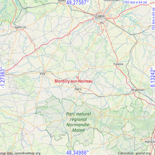
Montilly-sur-Noireau GPS coordinates[2]
48° 48' 54" North, 0° 34' 14.556" West
| Map corner | latitude | longitude |
|---|---|---|
| Upper-left | 49.27587°, | -1.27383° |
| Center: | 48.815°, | -0.57071° |
| Lower-right: | 48.34986°, | 0.13242° |
| Map W x H: | 103×103 km | = 64×64mi |
| max Lat: | 51.07786° ⇑24.2% North |
| Montilly-sur-Noireau: | 48.815° |
| min Lat: | ⇓75.8% South 41.3874° |
| min Long | Montilly-sur-No | max Long |
| -5.08615° | -0.57071° | 9.52242° |
| W 15.8%⇐ | ⇒84.2% E |
Elevation
Elevation of Montilly-sur-Noireau is 142 m = 466 ft, and this is 51.7 m = 170 ft below average elevation for this country.
| Max E: |
2333 m = 7654 ft | 47.2% |
| Avg. | 193.7 m = 635 ft | |
| Montilly-sur-Noireau | 142 m = 466 ft | |
Min E: |
-1 m = -3 ft | 52.8% |
See also: France elevation on elevation.city.
Geographical zone
Montilly-sur-Noireau is located in North temperate zone (between Tropic of Cancer and the Arctic Circle). Distance of this North polar circle is 1973.5 km =1226.3 mi to North.| Distance of | km | miles | from Montilly-sur-Noireau |
|---|---|---|---|
| North Pole | 4579.3 | 2845.4 | to North |
| Arctic Circle | 1973.5 | 1226.3 | to North |
| Tropic Cancer | 2821.8 | 1753.4 | to South |
| Equator | 5427.7 | 3372.6 | to South |


Nearby cities:
15 places around Montilly-sur-Noireau: (largest is in red/bold)
• Athis-de-l'Orne
5.2 km =3.2 mi,  87°
87°
• Berjou
7.6 km =4.7 mi,  59°
59°
• Caligny
1.9 km =1.2 mi,  246°
246°
• Condé-sur-Noireau
4 km =2.5 mi,  19°
19°
• Flers
8.7 km =5.4 mi,  181°
181°
• Frênes
8.8 km =5.5 mi, 247°
• La Lande-Patry
6.2 km =3.9 mi,  199°
199°
• Landisacq
8.7 km =5.4 mi,  221°
221°
• Montsecret
7.9 km =4.9 mi,  255°
255°
• Saint-Denis-de-Méré
7.2 km =4.5 mi,  32°
32°
• Saint-Georges-des-Groseillers
5 km =3.1 mi, 177°
• Saint-Germain-du-Crioult
5.2 km =3.2 mi,  331°
331°
• Saint-Pierre-du-Regard
3.6 km =2.2 mi, 29°
• Sainte-Honorine-la-Chardonne
6.3 km =3.9 mi,  80°
80°
• Vassy
8.8 km =5.5 mi,  299°
299°
Sources, notices
• [Note1] Compared only with cities in France existing in our database
• [Src1] Map data: © OpenStreetMap contributors (CC-BY-SA)
• [Src2] Other city data from geonames.org with taken over terms of usage.
• [Src3] Geographical zone / Annual Mean Temperature by Robert A. Rohde @ Wikipedia
