Montsecret geodata
Montsecret (Normandy) is a populated place; located in France in Europe/Paris (GMT+2) time zone. With population of 508 people, there are 15076 cities with bigger population in this country. Compared to other cities in France, 75.5% of cities are located further ↓South; 85.3% of cities are located further →East and 51.4% of cities have lower elevation than Montsecret. Note1
Administrative division(s):
- Level 1: Normandy
- Level 2: Département de l'Orne
- Level 3: Argentan
- Level 4: Montsecret-Clairefougère


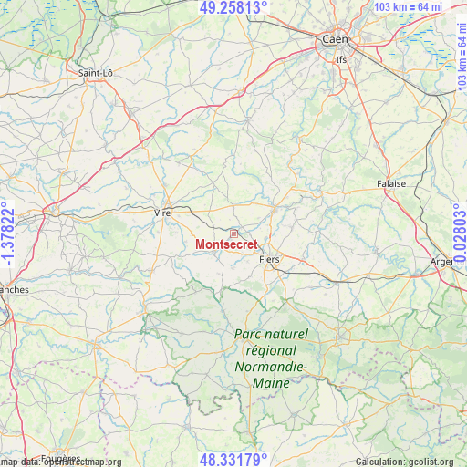
Montsecret GPS coordinates[2]
48° 47' 49.56" North, 0° 40' 30.36" West
| Map corner | latitude | longitude |
|---|---|---|
| Upper-left | 49.25813°, | -1.37822° |
| Center: | 48.7971°, | -0.6751° |
| Lower-right: | 48.33179°, | 0.02803° |
| Map W x H: | 103×103 km | = 64×64mi |
| max Lat: | 51.07786° ⇑24.5% North |
| Montsecret: | 48.7971° |
| min Lat: | ⇓75.5% South 41.3874° |
| min Long | Montsecret | max Long |
| -5.08615° | -0.6751° | 9.52242° |
| W 14.7%⇐ | ⇒85.3% E |
Elevation
Elevation of Montsecret is 137 m = 449 ft, and this is 56.7 m = 186 ft below average elevation for this country.
| Max E: |
2333 m = 7654 ft | 48.6% |
| Avg. | 193.7 m = 635 ft | |
| Montsecret | 137 m = 449 ft | |
Min E: |
-1 m = -3 ft | 51.4% |
See also: France elevation on elevation.city.
Geographical zone
Montsecret is located in North temperate zone (between Tropic of Cancer and the Arctic Circle). Distance of this North polar circle is 1975.4 km =1227.5 mi to North.| Distance of | km | miles | from Montsecret |
|---|---|---|---|
| North Pole | 4581.3 | 2846.7 | to North |
| Arctic Circle | 1975.4 | 1227.5 | to North |
| Tropic Cancer | 2819.8 | 1752.1 | to South |
| Equator | 5425.7 | 3371.4 | to South |


Nearby cities:
15 places around Montsecret: (largest is in red/bold)
• Bernières-le-Patry
4.9 km =3 mi,  292°
292°
• Caligny
6 km =3.7 mi,  78°
78°
• Chanu
7.6 km =4.7 mi,  180°
180°
• Flers
9.9 km =6.2 mi,  132°
132°
• Frênes
1.5 km =0.9 mi,  199°
199°
• La Lande-Patry
6.8 km =4.2 mi,  124°
124°
• Landisacq
4.9 km =3 mi,  157°
157°
• Le Theil-Bocage
10.1 km =6.3 mi,  342°
342°
• Montilly-sur-Noireau
7.9 km =4.9 mi, 75°
• Saint-Cornier-des-Landes
9.5 km =5.9 mi, 200°
• Saint-Georges-des-Groseillers
8.4 km =5.2 mi,  111°
111°
• Saint-Germain-du-Crioult
8.4 km =5.2 mi,  38°
38°
• Saint-Paul
6.8 km =4.2 mi,  153°
153°
• Tinchebray
5.6 km =3.5 mi,  229°
229°
• Vassy
6.3 km =3.9 mi,  0°
0°
Sources, notices
• [Note1] Compared only with cities in France existing in our database
• [Src1] Map data: © OpenStreetMap contributors (CC-BY-SA)
• [Src2] Other city data from geonames.org with taken over terms of usage.
• [Src3] Geographical zone / Annual Mean Temperature by Robert A. Rohde @ Wikipedia
