L'Estaque geodata
L'Estaque (Provence-Alpes-Côte d'Azur) is a section of populated place; located in France in Europe/Paris (GMT+2) time zone. With population of 6,391 people, there are 1547 cities with bigger population in this country. Compared to other cities in France, 94.7% of cities are located further ↑North; 80.7% of cities are located further ←West and 85.9% of cities have higher elevation than L'Estaque. Note1
Administrative division(s):
- Level 1: Provence-Alpes-Côte d'Azur
- Level 2: Département des Bouches-du-Rhône
- Level 3: Arrondissement de Marseille
- Level 4: Marseille


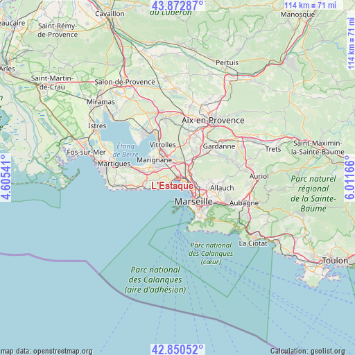
L'Estaque GPS coordinates[2]
43° 21' 49.86" North, 5° 18' 30.744" East
| Map corner | latitude | longitude |
|---|---|---|
| Upper-left | 43.87287°, | 4.60541° |
| Center: | 43.36385°, | 5.30854° |
| Lower-right: | 42.85052°, | 6.01166° |
| Map W x H: | 113.7×113.7 km | = 70.6×70.6mi |
| max Lat: | 51.07786° ⇑94.7% North |
| L'Estaque: | 43.36385° |
| min Lat: | ⇓5.3% South 41.3874° |
| min Long | L'Estaque | max Long |
| -5.08615° | 5.30854° | 9.52242° |
| W 80.7%⇐ | ⇒19.3% E |
Elevation
Elevation of L'Estaque is 40 m = 131 ft, and this is 153.7 m = 504 ft below average elevation for this country.
| Max E: |
2333 m = 7654 ft | 85.9% |
| Avg. | 193.7 m = 635 ft | |
| L'Estaque | 40 m = 131 ft | |
Min E: |
-1 m = -3 ft | 14.1% |
See also: France elevation on elevation.city.
Geographical zone
L'Estaque is located in North temperate zone (between Tropic of Cancer and the Arctic Circle). Distance of this Northern Tropic circle is 2215.7 km =1376.8 mi to South.| Distance of | km | miles | from L'Estaque |
|---|---|---|---|
| North Pole | 5185.5 | 3222.1 | to North |
| Arctic Circle | 2579.6 | 1602.9 | to North |
| Tropic Cancer | 2215.7 | 1376.8 | to South |
| Equator | 4821.6 | 2996 | to South |


Nearby cities:
15 places around L'Estaque: (largest is in red/bold)
• Borel
4.7 km =2.9 mi,  88°
88°
• La Calade
4.4 km =2.7 mi,  128°
128°
• La Viste
3.9 km =2.4 mi,  97°
97°
• Le Rove
4.7 km =2.9 mi,  278°
278°
• Les Aygalades
5.1 km =3.2 mi, 98°
• Les Pennes-Mirabeau
5.1 km =3.2 mi,  359°
359°
• Les Riaux
1.2 km =0.7 mi,  261°
261°
• Marseille 15
3.8 km =2.4 mi,  75°
75°
• Marseille 16
2.1 km =1.3 mi, 102°
• Notre-Dame Limite
4.8 km =3 mi,  65°
65°
• Saint-André
2.9 km =1.8 mi,  106°
106°
• Saint-Antoine
4.1 km =2.5 mi, 79°
• Saint-Henri
1.8 km =1.1 mi, 98°
• Saint-Louis
4.1 km =2.5 mi,  115°
115°
• Verduron
3.1 km =1.9 mi, 75°
Sources, notices
• [Note1] Compared only with cities in France existing in our database
• [Src1] Map data: © OpenStreetMap contributors (CC-BY-SA)
• [Src2] Other city data from geonames.org with taken over terms of usage.
• [Src3] Geographical zone / Annual Mean Temperature by Robert A. Rohde @ Wikipedia
