Les Pennes-Mirabeau geodata
Les Pennes-Mirabeau (Provence-Alpes-Côte d'Azur) is a populated place; located in France in Europe/Paris (GMT+2) time zone. With population of 19,871 people, there are 462 cities with bigger population in this country. Compared to other cities in France, 94.1% of cities are located further ↑North; 80.7% of cities are located further ←West and 57.4% of cities have lower elevation than Les Pennes-Mirabeau. Note1
Administrative division(s):
- Level 1: Provence-Alpes-Côte d'Azur
- Level 2: Département des Bouches-du-Rhône
- Level 3: Aix-en-Provence
- Level 4: Les Pennes-Mirabeau


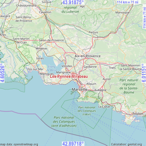
Les Pennes-Mirabeau GPS coordinates[2]
43° 24' 36.432" North, 5° 18' 30.168" East
| Map corner | latitude | longitude |
|---|---|---|
| Upper-left | 43.91875°, | 4.60526° |
| Center: | 43.41012°, | 5.30838° |
| Lower-right: | 42.89718°, | 6.01151° |
| Map W x H: | 113.6×113.6 km | = 70.6×70.6mi |
| max Lat: | 51.07786° ⇑94.1% North |
| Les Pennes-Mirabeau: | 43.41012° |
| min Lat: | ⇓5.9% South 41.3874° |
| min Long | Les Pennes-Mira | max Long |
| -5.08615° | 5.30838° | 9.52242° |
| W 80.7%⇐ | ⇒19.3% E |
Elevation
Elevation of Les Pennes-Mirabeau is 159 m = 522 ft, and this is 34.7 m = 114 ft below average elevation for this country.
| Max E: |
2333 m = 7654 ft | 42.6% |
| Avg. | 193.7 m = 635 ft | |
| Les Pennes-Mirabeau | 159 m = 522 ft | |
Min E: |
-1 m = -3 ft | 57.4% |
See also: France elevation on elevation.city.
Geographical zone
Les Pennes-Mirabeau is located in North temperate zone (between Tropic of Cancer and the Arctic Circle). Distance of this Northern Tropic circle is 2220.8 km =1379.9 mi to South.| Distance of | km | miles | from Les Pennes-Mirabeau |
|---|---|---|---|
| North Pole | 5180.3 | 3218.9 | to North |
| Arctic Circle | 2574.4 | 1599.7 | to North |
| Tropic Cancer | 2220.8 | 1379.9 | to South |
| Equator | 4826.8 | 2999.2 | to South |


Nearby cities:
15 places around Les Pennes-Mirabeau: (largest is in red/bold)
• Borel
6.9 km =4.3 mi,  136°
136°
• Cabriès
6.7 km =4.2 mi,  58°
58°
• Gignac-la-Nerthe
6.2 km =3.9 mi,  251°
251°
• L'Estaque
5.1 km =3.2 mi,  179°
179°
• Le Rove
6.4 km =4 mi,  225°
225°
• Les Riaux
5.4 km =3.4 mi,  192°
192°
• Marseille 15
5.6 km =3.5 mi, 138°
• Marseille 16
6 km =3.7 mi,  159°
159°
• Notre-Dame Limite
5.4 km =3.4 mi,  125°
125°
• Saint-André
6.6 km =4.1 mi,  154°
154°
• Saint-Antoine
6 km =3.7 mi, 136°
• Saint-Henri
5.7 km =3.5 mi, 161°
• Saint-Victoret
6.1 km =3.8 mi,  279°
279°
• Septèmes-les-Vallons
4.8 km =3 mi,  105°
105°
• Verduron
5.3 km =3.3 mi, 145°
In other languages:
- In France: Les Pennes-Mirabeau, Les-Pennes-Mirabeau
- In Russian: Ле-Пен-Мирабо
- In Chinese: 萊斯佩尼斯米拉波
Sources, notices
• [Note1] Compared only with cities in France existing in our database
• [Src1] Map data: © OpenStreetMap contributors (CC-BY-SA)
• [Src2] Other city data from geonames.org with taken over terms of usage.
• [Src3] Geographical zone / Annual Mean Temperature by Robert A. Rohde @ Wikipedia
