Verduron geodata
Verduron (Provence-Alpes-Côte d'Azur) is a section of populated place; located in France in Europe/Paris (GMT+2) time zone. With population of 8,846 people, there are 1085 cities with bigger population in this country. Compared to other cities in France, 94.6% of cities are located further ↑North; 81% of cities are located further ←West and 57.1% of cities have lower elevation than Verduron. Note1
Administrative division(s):
- Level 1: Provence-Alpes-Côte d'Azur
- Level 2: Département des Bouches-du-Rhône
- Level 3: Arrondissement de Marseille
- Level 4: Marseille


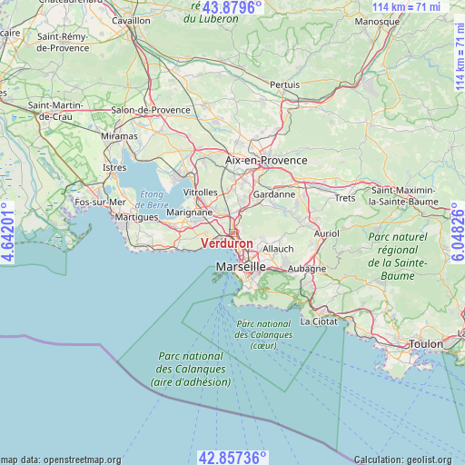
Verduron GPS coordinates[2]
43° 22' 14.268" North, 5° 20' 42.468" East
| Map corner | latitude | longitude |
|---|---|---|
| Upper-left | 43.8796°, | 4.64201° |
| Center: | 43.37063°, | 5.34513° |
| Lower-right: | 42.85736°, | 6.04826° |
| Map W x H: | 113.7×113.7 km | = 70.6×70.6mi |
| max Lat: | 51.07786° ⇑94.6% North |
| Verduron: | 43.37063° |
| min Lat: | ⇓5.4% South 41.3874° |
| min Long | Verduron | max Long |
| -5.08615° | 5.34513° | 9.52242° |
| W 81%⇐ | ⇒19% E |
Elevation
Elevation of Verduron is 158 m = 518 ft, and this is 35.7 m = 117 ft below average elevation for this country.
| Max E: |
2333 m = 7654 ft | 42.9% |
| Avg. | 193.7 m = 635 ft | |
| Verduron | 158 m = 518 ft | |
Min E: |
-1 m = -3 ft | 57.1% |
See also: France elevation on elevation.city.
Geographical zone
Verduron is located in North temperate zone (between Tropic of Cancer and the Arctic Circle). Distance of this Northern Tropic circle is 2216.4 km =1377.2 mi to South.| Distance of | km | miles | from Verduron |
|---|---|---|---|
| North Pole | 5184.7 | 3221.6 | to North |
| Arctic Circle | 2578.8 | 1602.4 | to North |
| Tropic Cancer | 2216.4 | 1377.2 | to South |
| Equator | 4822.4 | 2996.5 | to South |


Nearby cities:
15 places around Verduron: (largest is in red/bold)
• Borel
1.9 km =1.2 mi,  110°
110°
• L'Estaque
3.1 km =1.9 mi,  255°
255°
• La Calade
3.6 km =2.2 mi,  172°
172°
• La Delorme
3.7 km =2.3 mi,  143°
143°
• La Viste
1.6 km =1 mi, 143°
• Les Aygalades
2.6 km =1.6 mi,  125°
125°
• Marseille 15
0.7 km =0.4 mi,  75°
75°
• Marseille 16
1.5 km =0.9 mi,  216°
216°
• Notre-Dame Limite
1.9 km =1.2 mi,  49°
49°
• Saint-André
1.6 km =1 mi,  185°
185°
• Saint-Antoine
1.1 km =0.7 mi,  88°
88°
• Saint-Henri
1.5 km =0.9 mi,  229°
229°
• Saint-Joseph
3.9 km =2.4 mi, 134°
• Saint-Louis
2.6 km =1.6 mi,  162°
162°
• Septèmes-les-Vallons
3.5 km =2.2 mi,  28°
28°
Sources, notices
• [Note1] Compared only with cities in France existing in our database
• [Src1] Map data: © OpenStreetMap contributors (CC-BY-SA)
• [Src2] Other city data from geonames.org with taken over terms of usage.
• [Src3] Geographical zone / Annual Mean Temperature by Robert A. Rohde @ Wikipedia
