Lessy geodata
Lessy (Grand Est) is a populated place; located in France in Europe/Paris (GMT+2) time zone. With population of 863 people, there are 9962 cities with bigger population in this country. Compared to other cities in France, 82.6% of cities are located further ↓South; 88.1% of cities are located further ←West and 75.8% of cities have lower elevation than Lessy. Note1
Administrative division(s):
- Level 1: Grand Est
- Level 2: Moselle
- Level 3: Arrondissement de Metz
- Level 4: Lessy


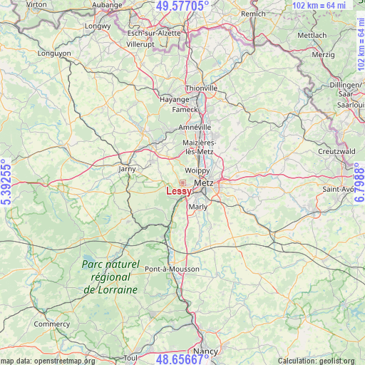
Lessy GPS coordinates[2]
49° 7' 8.364" North, 6° 5' 44.448" East
| Map corner | latitude | longitude |
|---|---|---|
| Upper-left | 49.57705°, | 5.39255° |
| Center: | 49.11899°, | 6.09568° |
| Lower-right: | 48.65667°, | 6.7988° |
| Map W x H: | 102.3×102.3 km | = 63.6×63.6mi |
| max Lat: | 51.07786° ⇑17.4% North |
| Lessy: | 49.11899° |
| min Lat: | ⇓82.6% South 41.3874° |
| min Long | Lessy | max Long |
| -5.08615° | 6.09568° | 9.52242° |
| W 88.1%⇐ | ⇒11.9% E |
Elevation
Elevation of Lessy is 255 m = 837 ft, and this is 61.3 m = 201 ft above average elevation for this country.
| Max E: |
2333 m = 7654 ft | 24.2% |
| Lessy | 255 m 837 ft | |
| Avg. | 193.7 m = 635 ft | |
Min E: |
-1 m = -3 ft | 75.8% |
See also: France elevation on elevation.city.
Geographical zone
Lessy is located in North temperate zone (between Tropic of Cancer and the Arctic Circle). Distance of this North polar circle is 1939.7 km =1205.3 mi to North.| Distance of | km | miles | from Lessy |
|---|---|---|---|
| North Pole | 4545.5 | 2824.4 | to North |
| Arctic Circle | 1939.7 | 1205.3 | to North |
| Tropic Cancer | 2855.6 | 1774.4 | to South |
| Equator | 5461.5 | 3393.6 | to South |


Nearby cities:
15 places around Lessy: (largest is in red/bold)
• Ars-sur-Moselle
4.8 km =3 mi,  198°
198°
• Châtel-Saint-Germain
1.2 km =0.7 mi,  289°
289°
• Gravelotte
4.9 km =3 mi,  258°
258°
• Le Ban Saint-Martin
4.1 km =2.5 mi,  84°
84°
• Longeville-lès-Metz
3 km =1.9 mi,  100°
100°
• Metz
5.6 km =3.5 mi,  89°
89°
• Montigny-lès-Metz
4.9 km =3 mi,  122°
122°
• Moulins-lès-Metz
1.9 km =1.2 mi,  150°
150°
• Plappeville
2.5 km =1.6 mi,  59°
59°
• Plesnois
6.1 km =3.8 mi,  7°
7°
• Rozérieulles
1.7 km =1.1 mi,  216°
216°
• Saulny
4.4 km =2.7 mi, 12°
• Scy-Chazelles
1.5 km =0.9 mi,  114°
114°
• Vaux
2.9 km =1.8 mi,  192°
192°
• Woippy
5.4 km =3.4 mi,  48°
48°
Sources, notices
• [Note1] Compared only with cities in France existing in our database
• [Src1] Map data: © OpenStreetMap contributors (CC-BY-SA)
• [Src2] Other city data from geonames.org with taken over terms of usage.
• [Src3] Geographical zone / Annual Mean Temperature by Robert A. Rohde @ Wikipedia
