Scy-Chazelles geodata
Scy-Chazelles (Grand Est) is a populated place; located in France in Europe/Paris (GMT+2) time zone. With population of 2,763 people, there are 3536 cities with bigger population in this country. Compared to other cities in France, 82.5% of cities are located further ↓South; 88.3% of cities are located further ←West and 65% of cities have lower elevation than Scy-Chazelles. Note1
Administrative division(s):
- Level 1: Grand Est
- Level 2: Moselle
- Level 3: Arrondissement de Metz
- Level 4: Scy-Chazelles


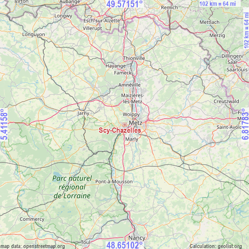
Scy-Chazelles GPS coordinates[2]
49° 6' 48.24" North, 6° 6' 52.92" East
| Map corner | latitude | longitude |
|---|---|---|
| Upper-left | 49.57151°, | 5.41158° |
| Center: | 49.1134°, | 6.1147° |
| Lower-right: | 48.65102°, | 6.81783° |
| Map W x H: | 102.3×102.3 km | = 63.6×63.6mi |
| max Lat: | 51.07786° ⇑17.5% North |
| Scy-Chazelles: | 49.1134° |
| min Lat: | ⇓82.5% South 41.3874° |
| min Long | Scy-Chazelles | max Long |
| -5.08615° | 6.1147° | 9.52242° |
| W 88.3%⇐ | ⇒11.7% E |
Elevation
Elevation of Scy-Chazelles is 194 m = 636 ft, and this is 0.30000000000001 m = 1 ft above average elevation for this country.
| Max E: |
2333 m = 7654 ft | 35% |
| Scy-Chazelles | 194 m 636 ft | |
| Avg. | 193.7 m = 635 ft | |
Min E: |
-1 m = -3 ft | 65% |
See also: France elevation on elevation.city.
Geographical zone
Scy-Chazelles is located in North temperate zone (between Tropic of Cancer and the Arctic Circle). Distance of this North polar circle is 1940.3 km =1205.6 mi to North.| Distance of | km | miles | from Scy-Chazelles |
|---|---|---|---|
| North Pole | 4546.2 | 2824.9 | to North |
| Arctic Circle | 1940.3 | 1205.6 | to North |
| Tropic Cancer | 2855 | 1774 | to South |
| Equator | 5460.9 | 3393.2 | to South |


Nearby cities:
15 places around Scy-Chazelles: (largest is in red/bold)
• Ars-sur-Moselle
4.9 km =3 mi,  216°
216°
• Augny
5.8 km =3.6 mi,  177°
177°
• Châtel-Saint-Germain
2.7 km =1.7 mi,  291°
291°
• Le Ban Saint-Martin
2.8 km =1.7 mi,  69°
69°
• Lessy
1.5 km =0.9 mi, 294°
• Longeville-lès-Metz
1.6 km =1 mi,  87°
87°
• Marly
6.2 km =3.9 mi,  152°
152°
• Metz
4.3 km =2.7 mi,  81°
81°
• Montigny-lès-Metz
3.4 km =2.1 mi,  125°
125°
• Moulins-lès-Metz
1.1 km =0.7 mi,  204°
204°
• Plappeville
2 km =1.2 mi,  21°
21°
• Rozérieulles
2.5 km =1.6 mi,  252°
252°
• Saulny
4.9 km =3 mi,  355°
355°
• Vaux
3 km =1.9 mi, 222°
• Woippy
5 km =3.1 mi,  32°
32°
Sources, notices
• [Note1] Compared only with cities in France existing in our database
• [Src1] Map data: © OpenStreetMap contributors (CC-BY-SA)
• [Src2] Other city data from geonames.org with taken over terms of usage.
• [Src3] Geographical zone / Annual Mean Temperature by Robert A. Rohde @ Wikipedia
