Lespinasse geodata
Lespinasse (Occitanie) is a populated place; located in France in Europe/Paris (GMT+2) time zone. With population of 2,435 people, there are 3974 cities with bigger population in this country. Compared to other cities in France, 90.2% of cities are located further ↑North; 64.5% of cities are located further →East and 53.1% of cities have higher elevation than Lespinasse. Note1
Administrative division(s):
- Level 1: Occitanie
- Level 2: Haute-Garonne
- Level 3: Arrondissement de Toulouse
- Level 4: Lespinasse


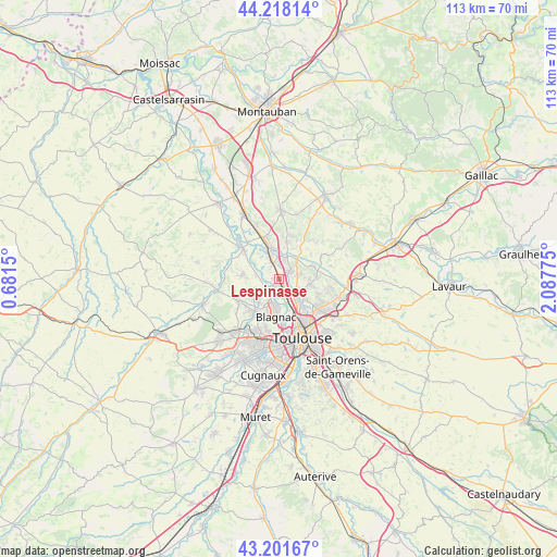
Lespinasse GPS coordinates[2]
43° 42' 43.416" North, 1° 23' 4.632" East
| Map corner | latitude | longitude |
|---|---|---|
| Upper-left | 44.21814°, | 0.6815° |
| Center: | 43.71206°, | 1.38462° |
| Lower-right: | 43.20167°, | 2.08775° |
| Map W x H: | 113×113 km | = 70.2×70.2mi |
| max Lat: | 51.07786° ⇑90.2% North |
| Lespinasse: | 43.71206° |
| min Lat: | ⇓9.8% South 41.3874° |
| min Long | Lespinasse | max Long |
| -5.08615° | 1.38462° | 9.52242° |
| W 35.5%⇐ | ⇒64.5% E |
Elevation
Elevation of Lespinasse is 122 m = 400 ft, and this is 71.7 m = 235 ft below average elevation for this country.
| Max E: |
2333 m = 7654 ft | 53.1% |
| Avg. | 193.7 m = 635 ft | |
| Lespinasse | 122 m = 400 ft | |
Min E: |
-1 m = -3 ft | 46.9% |
See also: France elevation on elevation.city.
Geographical zone
Lespinasse is located in North temperate zone (between Tropic of Cancer and the Arctic Circle). Distance of this Northern Tropic circle is 2254.4 km =1400.8 mi to South.| Distance of | km | miles | from Lespinasse |
|---|---|---|---|
| North Pole | 5146.7 | 3198 | to North |
| Arctic Circle | 2540.8 | 1578.8 | to North |
| Tropic Cancer | 2254.4 | 1400.8 | to South |
| Equator | 4860.3 | 3020 | to South |


Nearby cities:
15 places around Lespinasse: (largest is in red/bold)
• Aucamville
5.8 km =3.6 mi,  143°
143°
• Aussonne
6.3 km =3.9 mi,  237°
237°
• Beauzelle
5.1 km =3.2 mi,  188°
188°
• Bruguières
2.5 km =1.6 mi,  47°
47°
• Castelginest
4.5 km =2.8 mi,  116°
116°
• Cépet
5.6 km =3.5 mi,  42°
42°
• Fenouillet
3.6 km =2.2 mi,  170°
170°
• Fonbeauzard
5.5 km =3.4 mi,  133°
133°
• Gagnac-sur-Garonne
1.5 km =0.9 mi,  208°
208°
• Gratentour
4 km =2.5 mi,  71°
71°
• Pechbonnieu
6.6 km =4.1 mi,  99°
99°
• Saint-Alban
3 km =1.9 mi, 136°
• Saint-Jory
3.5 km =2.2 mi,  341°
341°
• Saint-Sauveur
4.2 km =2.6 mi,  17°
17°
• Seilh
3.1 km =1.9 mi,  230°
230°
Sources, notices
• [Note1] Compared only with cities in France existing in our database
• [Src1] Map data: © OpenStreetMap contributors (CC-BY-SA)
• [Src2] Other city data from geonames.org with taken over terms of usage.
• [Src3] Geographical zone / Annual Mean Temperature by Robert A. Rohde @ Wikipedia
