Saint-Jory geodata
Saint-Jory (Occitanie) is a populated place; located in France in Europe/Paris (GMT+2) time zone. With population of 4,564 people, there are 2166 cities with bigger population in this country. Compared to other cities in France, 89.8% of cities are located further ↑North; 64.7% of cities are located further →East and 53.8% of cities have higher elevation than Saint-Jory. Note1
Administrative division(s):
- Level 1: Occitanie
- Level 2: Haute-Garonne
- Level 3: Arrondissement de Toulouse
- Level 4: Saint-Jory


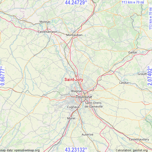
Saint-Jory GPS coordinates[2]
43° 44' 29.256" North, 1° 22' 15.204" East
| Map corner | latitude | longitude |
|---|---|---|
| Upper-left | 44.24729°, | 0.66777° |
| Center: | 43.74146°, | 1.37089° |
| Lower-right: | 43.23132°, | 2.07402° |
| Map W x H: | 113×113 km | = 70.2×70.2mi |
| max Lat: | 51.07786° ⇑89.8% North |
| Saint-Jory: | 43.74146° |
| min Lat: | ⇓10.2% South 41.3874° |
| min Long | Saint-Jory | max Long |
| -5.08615° | 1.37089° | 9.52242° |
| W 35.3%⇐ | ⇒64.7% E |
Elevation
Elevation of Saint-Jory is 120 m = 394 ft, and this is 73.7 m = 242 ft below average elevation for this country.
| Max E: |
2333 m = 7654 ft | 53.8% |
| Avg. | 193.7 m = 635 ft | |
| Saint-Jory | 120 m = 394 ft | |
Min E: |
-1 m = -3 ft | 46.2% |
See also: France elevation on elevation.city.
Geographical zone
Saint-Jory is located in North temperate zone (between Tropic of Cancer and the Arctic Circle). Distance of this Northern Tropic circle is 2257.7 km =1402.9 mi to South.| Distance of | km | miles | from Saint-Jory |
|---|---|---|---|
| North Pole | 5143.5 | 3196 | to North |
| Arctic Circle | 2537.6 | 1576.8 | to North |
| Tropic Cancer | 2257.7 | 1402.9 | to South |
| Equator | 4863.6 | 3022.1 | to South |


Nearby cities:
15 places around Saint-Jory: (largest is in red/bold)
• Bouloc
5.2 km =3.2 mi,  31°
31°
• Bruguières
3.3 km =2.1 mi,  118°
118°
• Castelginest
7.4 km =4.6 mi,  136°
136°
• Castelnau-d'Estrétefonds
4.8 km =3 mi,  348°
348°
• Cépet
5 km =3.1 mi,  80°
80°
• Fenouillet
7 km =4.3 mi,  165°
165°
• Gagnac-sur-Garonne
4.6 km =2.9 mi,  175°
175°
• Gratentour
5.3 km =3.3 mi,  111°
111°
• Lespinasse
3.5 km =2.2 mi,  161°
161°
• Merville
6.3 km =3.9 mi,  251°
251°
• Ondes
6.8 km =4.2 mi,  312°
312°
• Saint-Alban
6.3 km =3.9 mi,  149°
149°
• Saint-Sauveur
2.5 km =1.6 mi,  72°
72°
• Seilh
5.4 km =3.4 mi,  193°
193°
• Villeneuve-lès-Bouloc
5.1 km =3.2 mi,  55°
55°
Sources, notices
• [Note1] Compared only with cities in France existing in our database
• [Src1] Map data: © OpenStreetMap contributors (CC-BY-SA)
• [Src2] Other city data from geonames.org with taken over terms of usage.
• [Src3] Geographical zone / Annual Mean Temperature by Robert A. Rohde @ Wikipedia
