Le Pont-de-Beauvoisin geodata
Le Pont-de-Beauvoisin (Auvergne-Rhône-Alpes) is a populated place; located in France in Europe/Paris (GMT+2) time zone. With population of 2,829 people, there are 3445 cities with bigger population in this country. Compared to other cities in France, 73.6% of cities are located further ↑North; 84.2% of cities are located further ←West and 76.2% of cities have lower elevation than Le Pont-de-Beauvoisin. Note1
Administrative division(s):
- Level 1: Auvergne-Rhône-Alpes
- Level 2: Savoie
- Level 3: Arrondissement de Chambéry
- Level 4: Le Pont-de-Beauvoisin
Current local time in Le Pont-de-Beauvoisin:
09:58 AM, SaturdayDifference from your time zone: hours


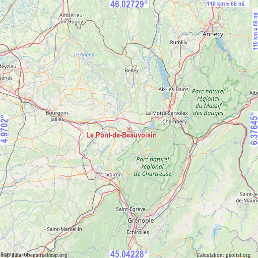
Le Pont-de-Beauvoisin GPS coordinates[2]
45° 32' 12.984" North, 5° 40' 23.988" East
| Map corner | latitude | longitude |
|---|---|---|
| Upper-left | 46.02729°, | 4.9702° |
| Center: | 45.53694°, | 5.67333° |
| Lower-right: | 45.04228°, | 6.37645° |
| Map W x H: | 109.5×109.5 km | = 68×68mi |
| max Lat: | 51.07786° ⇑73.6% North |
| Le Pont-de-Beauvoisin: | 45.53694° |
| min Lat: | ⇓26.4% South 41.3874° |
| min Long | Le Pont-de-Beau | max Long |
| -5.08615° | 5.67333° | 9.52242° |
| W 84.2%⇐ | ⇒15.8% E |
Elevation
Elevation of Le Pont-de-Beauvoisin is 258 m = 846 ft, and this is 64.3 m = 211 ft above average elevation for this country.
| Max E: |
2333 m = 7654 ft | 23.8% |
| Le Pont-de-Beauvoisin | 258 m 846 ft | |
| Avg. | 193.7 m = 635 ft | |
Min E: |
-1 m = -3 ft | 76.2% |
See also: France elevation on elevation.city.
Geographical zone
Le Pont-de-Beauvoisin is located in North temperate zone (between Tropic of Cancer and the Arctic Circle). Distance of this North polar circle is 2337.9 km =1452.7 mi to North.| Distance of | km | miles | from Le Pont-de-Beauvoisin |
|---|---|---|---|
| North Pole | 4943.8 | 3071.9 | to North |
| Arctic Circle | 2337.9 | 1452.7 | to North |
| Tropic Cancer | 2457.3 | 1526.9 | to South |
| Equator | 5063.2 | 3146.1 | to South |


Nearby cities:
15 places around Le Pont-de-Beauvoisin: (largest is in red/bold)
• Aoste
8.2 km =5.1 mi,  321°
321°
• Attignat-Oncin
8.7 km =5.4 mi,  111°
111°
• Charancieu
6.9 km =4.3 mi,  263°
263°
• Chimilin
7.4 km =4.6 mi,  304°
304°
• Domessin
2.7 km =1.7 mi,  64°
64°
• Fitilieu
8.8 km =5.5 mi,  277°
277°
• La Bridoire
5.4 km =3.4 mi,  104°
104°
• La Bâtie-Divisin
6.6 km =4.1 mi,  243°
243°
• Les Abrets
7.3 km =4.5 mi, 276°
• Montferrat
8.7 km =5.4 mi,  228°
228°
• Pressins
3.8 km =2.4 mi,  247°
247°
• Romagnieu
4.5 km =2.8 mi,  326°
326°
• Saint-Bueil
6.8 km =4.2 mi,  170°
170°
• Saint-Béron
5.7 km =3.5 mi,  131°
131°
• Saint-Genix-sur-Guiers
7.5 km =4.7 mi,  336°
336°
Sources, notices
• [Note1] Compared only with cities in France existing in our database
• [Src1] Map data: © OpenStreetMap contributors (CC-BY-SA)
• [Src2] Other city data from geonames.org with taken over terms of usage.
• [Src3] Geographical zone / Annual Mean Temperature by Robert A. Rohde @ Wikipedia
