Romagnieu geodata
Romagnieu (Auvergne-Rhône-Alpes) is a populated place; located in France in Europe/Paris (GMT+2) time zone. With population of 1,348 people, there are 6822 cities with bigger population in this country. Compared to other cities in France, 73% of cities are located further ↑North; 84% of cities are located further ←West and 76.5% of cities have lower elevation than Romagnieu. Note1
Administrative division(s):
- Level 1: Auvergne-Rhône-Alpes
- Level 2: Département de l'Isère
- Level 3: Arrondissement de La Tour-du-Pin
- Level 4: Romagnieu


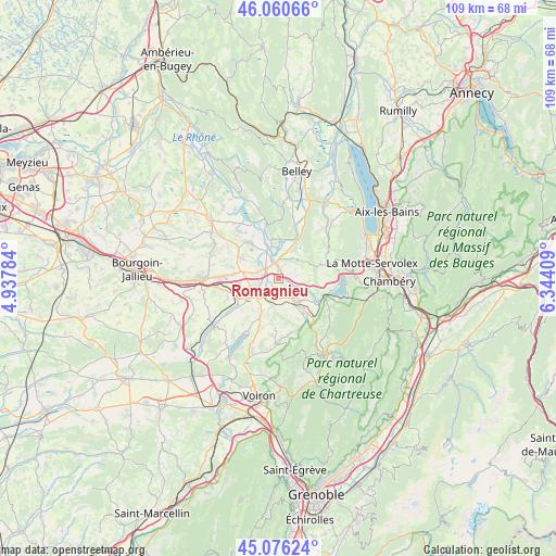
Romagnieu GPS coordinates[2]
45° 34' 14.196" North, 5° 38' 27.456" East
| Map corner | latitude | longitude |
|---|---|---|
| Upper-left | 46.06066°, | 4.93784° |
| Center: | 45.57061°, | 5.64096° |
| Lower-right: | 45.07624°, | 6.34409° |
| Map W x H: | 109.5×109.5 km | = 68×68mi |
| max Lat: | 51.07786° ⇑73% North |
| Romagnieu: | 45.57061° |
| min Lat: | ⇓27% South 41.3874° |
| min Long | Romagnieu | max Long |
| -5.08615° | 5.64096° | 9.52242° |
| W 84%⇐ | ⇒16% E |
Elevation
Elevation of Romagnieu is 260 m = 853 ft, and this is 66.3 m = 218 ft above average elevation for this country.
| Max E: |
2333 m = 7654 ft | 23.5% |
| Romagnieu | 260 m 853 ft | |
| Avg. | 193.7 m = 635 ft | |
Min E: |
-1 m = -3 ft | 76.5% |
See also: France elevation on elevation.city.
Geographical zone
Romagnieu is located in North temperate zone (between Tropic of Cancer and the Arctic Circle). Distance of this North polar circle is 2334.2 km =1450.4 mi to North.| Distance of | km | miles | from Romagnieu |
|---|---|---|---|
| North Pole | 4940.1 | 3069.6 | to North |
| Arctic Circle | 2334.2 | 1450.4 | to North |
| Tropic Cancer | 2461.1 | 1529.3 | to South |
| Equator | 5067 | 3148.5 | to South |


Nearby cities:
15 places around Romagnieu: (largest is in red/bold)
• Aoste
3.7 km =2.3 mi,  314°
314°
• Brégnier-Cordon
8 km =5 mi,  350°
350°
• Charancieu
6.2 km =3.9 mi,  223°
223°
• Chimilin
3.6 km =2.2 mi,  277°
277°
• Corbelin
8.7 km =5.4 mi,  298°
298°
• Domessin
5.6 km =3.5 mi,  117°
117°
• Fitilieu
6.7 km =4.2 mi,  247°
247°
• La Bridoire
9.3 km =5.8 mi, 123°
• La Bâtie-Divisin
7.5 km =4.7 mi,  206°
206°
• La Bâtie-Montgascon
8.8 km =5.5 mi,  274°
274°
• Le Pont-de-Beauvoisin
4.5 km =2.8 mi,  146°
146°
• Les Abrets
5.5 km =3.4 mi,  238°
238°
• Pressins
5.3 km =3.3 mi,  190°
190°
• Saint-André-le-Gaz
9.2 km =5.7 mi, 252°
• Saint-Genix-sur-Guiers
3.1 km =1.9 mi, 352°
Sources, notices
• [Note1] Compared only with cities in France existing in our database
• [Src1] Map data: © OpenStreetMap contributors (CC-BY-SA)
• [Src2] Other city data from geonames.org with taken over terms of usage.
• [Src3] Geographical zone / Annual Mean Temperature by Robert A. Rohde @ Wikipedia
