Aoste geodata
Aoste (Auvergne-Rhône-Alpes) is a populated place; located in France in Europe/Paris (GMT+2) time zone. With population of 1,958 people, there are 4886 cities with bigger population in this country. Compared to other cities in France, 72.7% of cities are located further ↑North; 83.8% of cities are located further ←West and 70.4% of cities have lower elevation than Aoste. Note1
Administrative division(s):
- Level 1: Auvergne-Rhône-Alpes
- Level 2: Département de l'Isère
- Level 3: Arrondissement de La Tour-du-Pin
- Level 4: Aoste


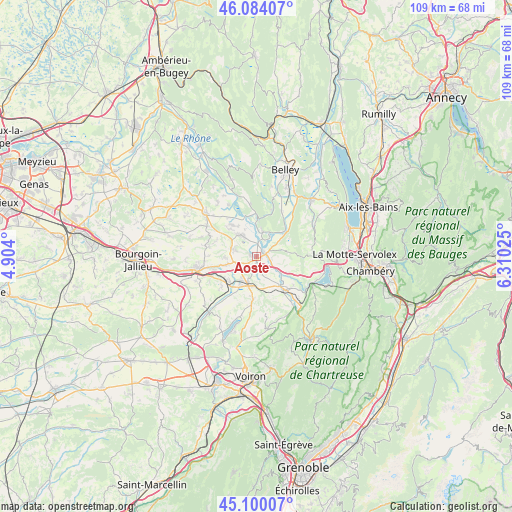
Aoste GPS coordinates[2]
45° 35' 39.228" North, 5° 36' 25.632" East
| Map corner | latitude | longitude |
|---|---|---|
| Upper-left | 46.08407°, | 4.904° |
| Center: | 45.59423°, | 5.60712° |
| Lower-right: | 45.10007°, | 6.31025° |
| Map W x H: | 109.4×109.4 km | = 68×68mi |
| max Lat: | 51.07786° ⇑72.7% North |
| Aoste: | 45.59423° |
| min Lat: | ⇓27.3% South 41.3874° |
| min Long | Aoste | max Long |
| -5.08615° | 5.60712° | 9.52242° |
| W 83.8%⇐ | ⇒16.2% E |
Elevation
Elevation of Aoste is 221 m = 725 ft, and this is 27.3 m = 90 ft above average elevation for this country.
| Max E: |
2333 m = 7654 ft | 29.6% |
| Aoste | 221 m 725 ft | |
| Avg. | 193.7 m = 635 ft | |
Min E: |
-1 m = -3 ft | 70.4% |
See also: France elevation on elevation.city.
Geographical zone
Aoste is located in North temperate zone (between Tropic of Cancer and the Arctic Circle). Distance of this North polar circle is 2331.6 km =1448.8 mi to North.| Distance of | km | miles | from Aoste |
|---|---|---|---|
| North Pole | 4937.5 | 3068 | to North |
| Arctic Circle | 2331.6 | 1448.8 | to North |
| Tropic Cancer | 2463.7 | 1530.9 | to South |
| Equator | 5069.6 | 3150.1 | to South |


Nearby cities:
15 places around Aoste: (largest is in red/bold)
• Brégnier-Cordon
5.4 km =3.4 mi,  14°
14°
• Charancieu
7.3 km =4.5 mi,  193°
193°
• Chimilin
2.3 km =1.4 mi,  202°
202°
• Corbelin
5.2 km =3.2 mi,  286°
286°
• Domessin
9.2 km =5.7 mi,  124°
124°
• Faverges-de-la-Tour
6.7 km =4.2 mi,  266°
266°
• Fitilieu
6.3 km =3.9 mi,  214°
214°
• La Bâtie-Montgascon
6.4 km =4 mi,  252°
252°
• Le Pont-de-Beauvoisin
8.2 km =5.1 mi,  141°
141°
• Les Abrets
5.9 km =3.7 mi, 200°
• Les Avenières
5.9 km =3.7 mi,  322°
322°
• Pressins
8 km =5 mi,  168°
168°
• Romagnieu
3.7 km =2.3 mi,  134°
134°
• Saint-André-le-Gaz
8.2 km =5.1 mi,  228°
228°
• Saint-Genix-sur-Guiers
2.3 km =1.4 mi,  77°
77°
Sources, notices
• [Note1] Compared only with cities in France existing in our database
• [Src1] Map data: © OpenStreetMap contributors (CC-BY-SA)
• [Src2] Other city data from geonames.org with taken over terms of usage.
• [Src3] Geographical zone / Annual Mean Temperature by Robert A. Rohde @ Wikipedia
