Le Breuil-sur-Couze geodata
Le Breuil-sur-Couze (Auvergne-Rhône-Alpes) is a populated place; located in France in Europe/Paris (GMT+2) time zone. With population of 1,020 people, there are 8683 cities with bigger population in this country. Compared to other cities in France, 74.5% of cities are located further ↑North; 61.5% of cities are located further ←West and 88.3% of cities have lower elevation than Le Breuil-sur-Couze. Note1
Administrative division(s):
- Level 1: Auvergne-Rhône-Alpes
- Level 2: Département du Puy-de-Dôme
- Level 3: Issoire
- Level 4: Le Breuil-sur-Couze


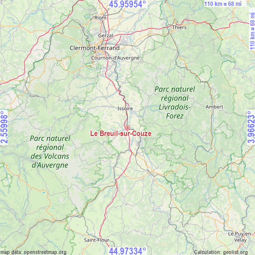
Le Breuil-sur-Couze GPS coordinates[2]
45° 28' 6.96" North, 3° 15' 47.16" East
| Map corner | latitude | longitude |
|---|---|---|
| Upper-left | 45.95954°, | 2.55998° |
| Center: | 45.4686°, | 3.2631° |
| Lower-right: | 44.97334°, | 3.96623° |
| Map W x H: | 109.7×109.7 km | = 68.2×68.2mi |
| max Lat: | 51.07786° ⇑74.5% North |
| Le Breuil-sur-Couze: | 45.4686° |
| min Lat: | ⇓25.5% South 41.3874° |
| min Long | Le Breuil-sur-C | max Long |
| -5.08615° | 3.2631° | 9.52242° |
| W 61.5%⇐ | ⇒38.5% E |
Elevation
Elevation of Le Breuil-sur-Couze is 393 m = 1289 ft, and this is 199.3 m = 654 ft above average elevation for this country.
| Max E: |
2333 m = 7654 ft | 11.7% |
| Le Breuil-sur-Couze | 393 m 1289 ft | |
| Avg. | 193.7 m = 635 ft | |
Min E: |
-1 m = -3 ft | 88.3% |
See also: France elevation on elevation.city.
Geographical zone
Le Breuil-sur-Couze is located in North temperate zone (between Tropic of Cancer and the Arctic Circle). Distance of this North polar circle is 2345.5 km =1457.4 mi to North.| Distance of | km | miles | from Le Breuil-sur-Couze |
|---|---|---|---|
| North Pole | 4951.4 | 3076.7 | to North |
| Arctic Circle | 2345.5 | 1457.4 | to North |
| Tropic Cancer | 2449.7 | 1522.2 | to South |
| Equator | 5055.6 | 3141.4 | to South |


Nearby cities:
15 places around Le Breuil-sur-Couze: (largest is in red/bold)
• Auzat-la-Combelle
4.7 km =2.9 mi,  112°
112°
• Auzon
12.1 km =7.5 mi,  134°
134°
• Brassac-les-Mines
7.9 km =4.9 mi,  139°
139°
• Charbonnier-les-Mines
6 km =3.7 mi,  163°
163°
• Issoire
8.5 km =5.3 mi,  352°
352°
• Jumeaux
7.3 km =4.5 mi,  124°
124°
• Lamontgie
5.5 km =3.4 mi,  83°
83°
• Le Broc
3.9 km =2.4 mi,  337°
337°
• Lempdes-sur-Allagnon
9.6 km =6 mi,  170°
170°
• Orbeil
10.5 km =6.5 mi,  5°
5°
• Parentignat
7.6 km =4.7 mi,  16°
16°
• Perrier
10.1 km =6.3 mi,  328°
328°
• Saint-Germain-Lembron
2.2 km =1.4 mi,  236°
236°
• Sainte-Florine
8.2 km =5.1 mi,  149°
149°
• Vergongheon
11.7 km =7.3 mi, 157°
Sources, notices
• [Note1] Compared only with cities in France existing in our database
• [Src1] Map data: © OpenStreetMap contributors (CC-BY-SA)
• [Src2] Other city data from geonames.org with taken over terms of usage.
• [Src3] Geographical zone / Annual Mean Temperature by Robert A. Rohde @ Wikipedia
